

 Carol wanted no part of another 28 degree sunrise, so I ventured off on my own. I decided to do Bryce Point this time.
In the past, we've usually done sunrise at Sunset Point, but I wanted to zero in on the Silent City.
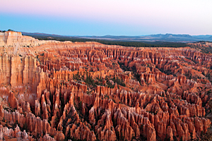
I arrived at Bryce Point
Carol wanted no part of another 28 degree sunrise, so I ventured off on my own. I decided to do Bryce Point this time.
In the past, we've usually done sunrise at Sunset Point, but I wanted to zero in on the Silent City.
I arrived at Bryce Point![]() about 20 minutes before sunrise, but there must have been 20 cars in the parking lot. Needless to say,
all the prime shooting locations at the point were taken...two deep. I found a spot back from the point and set up.
The temperature was just below freezing, but it was a gorgeous morning. There was no breeze and not a cloud in the sky.
Not great for photography, but it felt much warmer than the 29 degrees that it was.
about 20 minutes before sunrise, but there must have been 20 cars in the parking lot. Needless to say,
all the prime shooting locations at the point were taken...two deep. I found a spot back from the point and set up.
The temperature was just below freezing, but it was a gorgeous morning. There was no breeze and not a cloud in the sky.
Not great for photography, but it felt much warmer than the 29 degrees that it was.
 The sun finally peaked above the ridges in the east and started painting the hoodoos with light. As the light
progressed across the amphitheater below, the hoodoos started lighting and the shadows lengthened. In a few minutes,
the ridge called The Wall of Windows was completely lit. This has always been my favorite area of Bryce and the destination
of my canyon hike for most trips. It's a lot easier to photograph it from here than the 4 mile hike on the Navajo and
Peekaboo Trails to shoot there.
The sun finally peaked above the ridges in the east and started painting the hoodoos with light. As the light
progressed across the amphitheater below, the hoodoos started lighting and the shadows lengthened. In a few minutes,
the ridge called The Wall of Windows was completely lit. This has always been my favorite area of Bryce and the destination
of my canyon hike for most trips. It's a lot easier to photograph it from here than the 4 mile hike on the Navajo and
Peekaboo Trails to shoot there.
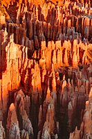
With no clouds in the sky, the best light was gone in 15 minutes and the point started clearing out. I moved to my long lens and started isolating hoodoos against darker shadows behind them. By the time I was ready to quit, I was the only person at Bryce Point. I would love to shoot here again when there are clouds over the canyon. The combination of the Wall of Windows and the Silent City could make for some outstanding images.
By the time I returned to camp, it was a balmy 33 degrees, but it was going to be another beautiful day.
After lunch, we decided to check out the hike to Mossy Cave and the road conditions to Grosvenor Arch. We had driven out to Grosvenor Arch two years ago and were surprised by the images we got. It is an amazing area. Somehow in the process of downloading images, formatting CF cards, and organizing my images, I managed to erase all my Grosvenor Arch images. Ouch!
When we got to the Grand Staircase-Escalante Visitor Center in Cannonville, we heard the words again, "The road is closed." This time the ranger added, "There are boggy areas that are swallowing cars." Some people had gotten stuck the night before and had to hike out to get help the next morning. We wanted no part of that. Then he mentioned that the Skutumpah Road was being graded and was open. Included on the Skutumpah Road was Willis Creek, one of the slot canyons we had planned to hike while staying in Escalante. That was great news. At least we'd get to do one slot canyon on this trip.
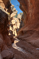 Willis Creek
![]() didn't disappoint us in any way. The hike into the canyon was very easy and the entire slot
canyon seemed nearly level. It is nothing like the slot canyons we've visited around Page, but it had its own
charm. Willis Creek had a small stream that was constantly gurgling as it flowed over the tiny stones of the streambed.
didn't disappoint us in any way. The hike into the canyon was very easy and the entire slot
canyon seemed nearly level. It is nothing like the slot canyons we've visited around Page, but it had its own
charm. Willis Creek had a small stream that was constantly gurgling as it flowed over the tiny stones of the streambed.
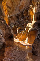 From time to time, a bass voice joined the chorus as the stream dropped over a small ledge and into a deeper pool.
As we continued down the canyon, the walls kept getting higher until one area in the second narrows where they were about
80 feet high. The width of the canyon varied back and forth between 15 feet wide and 2 feet wide, but the stream was
never over an inch or two deep. As we hiked through the first set of narrows, we met a few hikers coming out,
but after the first 30 minutes, we had the whole canyon to ourselves. There seemed to be new things to shoot
at every corner, so our progress down the canyon was incredibly slow. When we reached the end of the second
narrows, we decided we needed to turn back because it was nearly 6:00 and we didn't want to get caught
in the canyon after dark. But even as we hiked out of the canyon, we couldn't help but stop to photograph
the areas we missed while hiking down the canyon. We finally hiked out of the canyon shortly before dark,
and even managed to drive to the paved road before it got pitch dark.
From time to time, a bass voice joined the chorus as the stream dropped over a small ledge and into a deeper pool.
As we continued down the canyon, the walls kept getting higher until one area in the second narrows where they were about
80 feet high. The width of the canyon varied back and forth between 15 feet wide and 2 feet wide, but the stream was
never over an inch or two deep. As we hiked through the first set of narrows, we met a few hikers coming out,
but after the first 30 minutes, we had the whole canyon to ourselves. There seemed to be new things to shoot
at every corner, so our progress down the canyon was incredibly slow. When we reached the end of the second
narrows, we decided we needed to turn back because it was nearly 6:00 and we didn't want to get caught
in the canyon after dark. But even as we hiked out of the canyon, we couldn't help but stop to photograph
the areas we missed while hiking down the canyon. We finally hiked out of the canyon shortly before dark,
and even managed to drive to the paved road before it got pitch dark.
On our way back to camp, the GPS told us (blue tooth connection to cell phone) we had missed a call from Matt. Carol called him back, and we learned that Matt and Jackie were engaged. The day just kept getting better.
We ended the day with chili for dinner as we downloaded all our images for the day. Then it was time for a shower. It was a great day!