

Today dawned clear and sunny. It was a gorgeous day. We have heard that this was an especially tough spring around Portland. They had 90 straight days where it rained. It was obvious today that everyone in Portland was ready for a sunny weekend.
Our first priority was to drive to Trillium Lake to verify that we would have Mi-Fi coverage next week so I can work from the motorhome. That meant circling Mt. Hood. We drove by a hot rod show, great wildflowers, farms growing Japanese maples, crowded trailhead parking lots, and lots of serious bike riders on the west side of Mt. Hood.
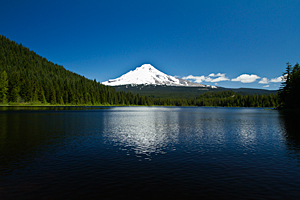 Trillium Lake
![]() was beautiful even in mid-morning light. The Forest Service used some of the Stimulus money to improve the facilities
along the shoreline. They brought in huge boulders and backfilled behind them to make new fishing areas;
each of which seemed to be filled with families fishing. We didn't see a lot of people catching fish,
but everyone seemed to be enjoying the day. It was certainly an improvement over the muddy banks that we had seen previous years.
was beautiful even in mid-morning light. The Forest Service used some of the Stimulus money to improve the facilities
along the shoreline. They brought in huge boulders and backfilled behind them to make new fishing areas;
each of which seemed to be filled with families fishing. We didn't see a lot of people catching fish,
but everyone seemed to be enjoying the day. It was certainly an improvement over the muddy banks that we had seen previous years.
After verifying that we had Mi-Fi coverage at Trillium, we continued our tour of Mt. Hood as we drove around the east side of the mountain.
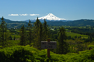
We stopped at Panorama Point![]() for a different view of Mt. Hood. We're used to seeing it behind a gorgeous mountain lake or above fir-covered mountains. From Panorama Point,
Mt. Hood towers over a valley filled with fruit orchards. It has a completely different feel and must be amazing
when all the fruit trees are blooming in the spring.
for a different view of Mt. Hood. We're used to seeing it behind a gorgeous mountain lake or above fir-covered mountains. From Panorama Point,
Mt. Hood towers over a valley filled with fruit orchards. It has a completely different feel and must be amazing
when all the fruit trees are blooming in the spring.
Then we dropped down into the Columbia River Gorge to check out the other waterfalls we hadn't seen. That was when the reality set in that half of Portland was in The Gorge.
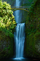
We lucked out and found a parking place at Multnomah Falls,![]() but it was a zoo. There were hoards of people everywhere. We quickly got our shots and moved on. The bright sunshine made for a
beautiful day, but the high contrast made shooting tough.
but it was a zoo. There were hoards of people everywhere. We quickly got our shots and moved on. The bright sunshine made for a
beautiful day, but the high contrast made shooting tough.
|
|
| Multnomah Falls | Multnomah Falls |
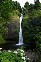
The next stop was Shepherd's Dell. We had seen the sign last night for Shepherd's Dell but bypassed photographing it. After seeing a photo of the falls, we decided to check it out today. This was a very tough waterfall to photograph. The end of the trail provided a good shot of the mid section of the falls, but no way to shoot the top or bottom sections. Shooting from near the road provided an angle to the bottom section, but the trees blocked the top section.
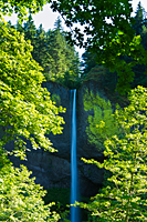
After Shepherd's Dell, we returned to Latourell Falls. We shot the falls from the bottom of the canyon yesterday, but later realized that there was another viewpoint from a trail above the parking lot. We climbed a short hill where we had a straight-on view of the falls.
It was early evening by the time we finished at Latourell Falls, so we decided to drive back up the gorge to see
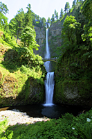
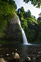
about shooting waterfalls that were too crowded earlier in the afternoon. We drove back to Horsetail
Falls![]() , which drops 192 feet down a cliff into a pool at the bottom. The early evening lighting was good, and the cow
parsnip provided an interesting foreground.
, which drops 192 feet down a cliff into a pool at the bottom. The early evening lighting was good, and the cow
parsnip provided an interesting foreground.
|
|
|
| Latourell Falls | Horsetail Falls | Horsetail Falls |
By the time we finished with Horsetail Falls, we were ready to call it a day. We drove back to camp, enjoyed a spaghetti dinner, and watched "Secretariat." It was a good day.