

Today is our most adventurous day as we hike to Budd Lake.![]() There is no maintained trail to Budd Lake,
but I did this hike with friends about 25 years ago. I had no problem finding it then. It was an area of
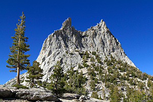
stark beauty with the lake right up against the granite cliffs of Unicorn Peak, the Cockscomb, and Echo Peak.
I've looked forward to doing this hike again for a number of years; especially because Carol and I enjoyed
the hike to Elizabeth Lake a few years ago. Elizabeth Lake is just on the other side of the Unicorn Peak ridge.
The hike is 4.4 miles and climbs over 1,000 feet, so it will be a tough day. I'm hoping that taking it slowly
with lots of breaks will mitigate the 25 years of lost energy and conditioning since the last time I did this hike.
There is no maintained trail to Budd Lake,
but I did this hike with friends about 25 years ago. I had no problem finding it then. It was an area of
stark beauty with the lake right up against the granite cliffs of Unicorn Peak, the Cockscomb, and Echo Peak.
I've looked forward to doing this hike again for a number of years; especially because Carol and I enjoyed
the hike to Elizabeth Lake a few years ago. Elizabeth Lake is just on the other side of the Unicorn Peak ridge.
The hike is 4.4 miles and climbs over 1,000 feet, so it will be a tough day. I'm hoping that taking it slowly
with lots of breaks will mitigate the 25 years of lost energy and conditioning since the last time I did this hike.
We reached Tuolumne Meadows and the parking area for the trailhead shortly before noon. There were far fewer cars than over the weekend, so we had no problem finding a parking place. It took us a few minutes to get everything organized so we would be carrying a minimum of weight and still have everything we needed. It was going to be a warm day, so we needed extra water.
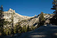
There is a "superhighway" from Tuolumne Meadows to the Cathedral Lakes. Somewhere around 8800 feet in elevation, we had to leave the main trail and find a climber's trail that would take us toward Budd Lake. The trail started climbing immediately after leaving the parking area and continued to climb the entire time. It was only a question of how steep the climb was. We found the "junction" to the climber's trail with no problem. The trail narrowed and we often depended on duck markers to find the next stretch. After a couple hours, we reached a saddle that seemed to be the ridge where we would cut across to Budd Lake. The map and GPS said it was too soon, but everything looked right. It was a bit crushing when we continued to climb, and it became obvious we were still at least a mile and 500 feet below the lake. To make matters worse, the trail seemed to be climbing a ridge that led us toward Cathedral Peak and away from Budd Creek. That was a bad sign. Sometime during the 25 year absence, the Park Service had closed some sensitive areas that forced the re-routing the climbers trail. We later discovered that the trail to Budd Lake had also been re-routed to the other side of Budd Creek, and we had missed the crossing.
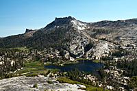
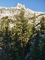
We finally climbed high enough on the ridge below Cathedral Peak that we could see Budd Lake. It appeared that we could drop down through the trees, go around the head of Budd Creek, and climb the ridge to Budd Lake. That was a lot of up and down. Instead, we decided to continue climbing the ridge below Cathedral Peak for a view down into the Cathedral Lakes. I remembered hiking in this area after we had explored Budd Lake on the previous trip. The ridge took us to the base of Cathedral Peak, providing an up-close and personal view.
|
|
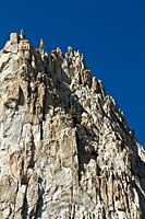
There were several sets of climbers on the mountain. One of the routes led them up a knife-blade edge of the final "steeple." Their bodies were silhouetted against the sky as they made the final pitch. We met two climbers on the trail on the way back down as they literally ran down the mountain. Showoffs!
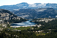
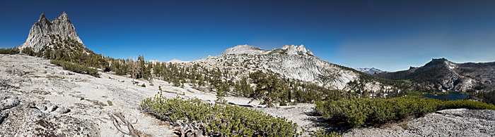
When we reached the west edge of the ridge![]() (37 degrees 50.657'N, 119 degrees 24.632' W),
we had an amazing view that stretched for miles and miles. Directly below us were Upper and Lower Cathedral Lakes
and the verdant green meadow that connects them. Lower Cathedral Lake is embraced by the arms of two granite ridges.
Its outlet drops over the granite cliff to be seen from the Tioga Pass Road near Pywiack Dome 1,000 below. Looking
south past Tresidder Peak and Columbia Finger, we could see the valley holding Merced Lake and the peaks
of the Clark Range. To the north, we looked over the Tioga Pass Road and countless domes toward the Glen Aulin area.
It was like an aerial view without the airplane.
(37 degrees 50.657'N, 119 degrees 24.632' W),
we had an amazing view that stretched for miles and miles. Directly below us were Upper and Lower Cathedral Lakes
and the verdant green meadow that connects them. Lower Cathedral Lake is embraced by the arms of two granite ridges.
Its outlet drops over the granite cliff to be seen from the Tioga Pass Road near Pywiack Dome 1,000 below. Looking
south past Tresidder Peak and Columbia Finger, we could see the valley holding Merced Lake and the peaks
of the Clark Range. To the north, we looked over the Tioga Pass Road and countless domes toward the Glen Aulin area.
It was like an aerial view without the airplane.
We shot all along the ridge for an hour, but the wind was coming up and we needed to get back down the mountain before dark. We hiked back over the spine of the ridge to the Budd Lake side and took some panorama shots of the peaks above Budd Lake before working our way back to the climber's trail.
|
|
|
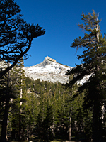
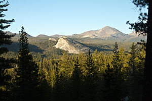
We never made it to Budd Lake. By this point, we had already hiked over 4 miles and climbed 1500 feet. We were dead tired and it was 5:45. One advantage of hiking back later in the afternoon was the warm light on the peaks as we hiked back down. We made several stops to photograph the peaks and Tuolumne Meadows far below. A marmot posed for us and provided an excuse to rest partway down the trail. He was extremely curious and kept moving and popping up to get views from different angles. As soon as I got my longer lens on my camera, he became bored with us and ambled up the ridge.
|
|
|
We finally reached Tuolumne Meadows and the Explorer about 8:00. When I looked down at the GPS, it said we had hiked exactly 7 miles. That is a huge difference from the 4.2 miles we had planned to do. We didn't care about shooting sunset or anything else at this point. All we wanted was to get back to camp. It had been a LONG day. It had certainly been a lot easier 25 years ago.