

We woke up to overcast skies and temperatures in the 60's. But by the time we ventured out to the Columbia River Gorge, the sun had burned through and the temperatures were headed toward the 90's with very high humidity.
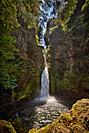 Our first stop was Wahclella Falls
![]() .
It was only a mile in with a 350-foot elevation gain. Ordinarily, that would be an easy hike. Not today. With the heat and humidity,
we were soaked in minutes. Wahclellah Falls is one of the best falls in the gorge, but our timing was awful. Wahclellah Falls drops
through a narrow chute into an dark alcove. The contrast between the dark alcove and any area with sunlight was impossible to deal with.
We definitely need to go back on a bright overcast day. If we had left as soon as we got up today, it would have been perfect.
We'll try to do better when we return in August.
.
It was only a mile in with a 350-foot elevation gain. Ordinarily, that would be an easy hike. Not today. With the heat and humidity,
we were soaked in minutes. Wahclellah Falls is one of the best falls in the gorge, but our timing was awful. Wahclellah Falls drops
through a narrow chute into an dark alcove. The contrast between the dark alcove and any area with sunlight was impossible to deal with.
We definitely need to go back on a bright overcast day. If we had left as soon as we got up today, it would have been perfect.
We'll try to do better when we return in August.
We were wiped out by the time we got back to the Explorer. We forgot all about the other waterfalls we had planned to photograph and drove back to camp. We grilled hamburgers for a special treat and then napped through the heat of the day.
 At 5:30,
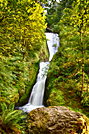
we returned to Bridal Veil Falls
At 5:30,
we returned to Bridal Veil Falls![]() , our favorite waterfall in the gorge.
It's less than a one-mile hike and it's all shaded. The two-tier waterfall starts just below the highway and drops into the shady glen
of Bridal Veil Creek. When we arrived, a young couple was jumping off a rock into the lower plunge pool. The pool wasn't that deep,
but they seemed to be having a great time. We met a family along the trail celebrating the father's 80th birthday and discovered
the son lives in Capistrano; just up the road from one of our favorite campgrounds. The parents shared some of their favorite stories
of the Columbia River Gorge, including the day that Multnomah Falls was running so high that the top tier of the falls crashed
down on Benson Bridge instead of into its plunge pool. That is a serious "leap" from the edge of the plateau.
, our favorite waterfall in the gorge.
It's less than a one-mile hike and it's all shaded. The two-tier waterfall starts just below the highway and drops into the shady glen
of Bridal Veil Creek. When we arrived, a young couple was jumping off a rock into the lower plunge pool. The pool wasn't that deep,
but they seemed to be having a great time. We met a family along the trail celebrating the father's 80th birthday and discovered
the son lives in Capistrano; just up the road from one of our favorite campgrounds. The parents shared some of their favorite stories
of the Columbia River Gorge, including the day that Multnomah Falls was running so high that the top tier of the falls crashed
down on Benson Bridge instead of into its plunge pool. That is a serious "leap" from the edge of the plateau.
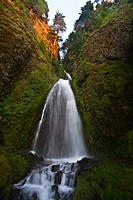 Our second stop was Wahkeenah Falls
![]() , but this time Carol sat out the hike. It was only about 1/4 mile each way, but it climbed a ridge to reach
the base of the falls. Carol had done enough climbing for today. The thing that makes Wahkeenah Falls cool (literally and figuratively)
is that the trail crosses the creek right at the base of the falls. Showers are provided for all who hope to pass. It makes for great images,
but it's also a challenge to shoot without getting water spots on the images. I had to continually stop and wipe off my lens. Even though
it was nearly 8:30, the mist from the falls felt wonderful.
, but this time Carol sat out the hike. It was only about 1/4 mile each way, but it climbed a ridge to reach
the base of the falls. Carol had done enough climbing for today. The thing that makes Wahkeenah Falls cool (literally and figuratively)
is that the trail crosses the creek right at the base of the falls. Showers are provided for all who hope to pass. It makes for great images,
but it's also a challenge to shoot without getting water spots on the images. I had to continually stop and wipe off my lens. Even though
it was nearly 8:30, the mist from the falls felt wonderful.
After cleaning my lens off for the last time and disconnecting my remote control, I turned around and almost jumped into the canyon. Not 10 feet away was a deer. We both jumped, but I tried to reassure her that I wouldn't bother her. She backed up and started down toward the creek. I continued talking to her as I increased my camera's ISO enough to actually get a shot of her. Of course, I had my 10-22 super wide-angle lens on the camera instead of anything that would actually work for wildlife. She paused a few feet from the trail and watched me as I slowly moved past her. We congratulated each other on our detente and went about our business.