

Who in their right mind gets up at 4:30 while on vacation? I guess we do. But only under severe duress. We normally travel in the spring and fall when sunrise is around 7:00 and sunset is about 6:30 or 7:00. Now, sunrise is at 5:30 and sunset is at 8:58. That makes for some very long days. Today, was a very long day.
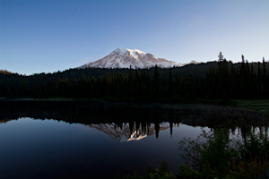
Reflection Lake
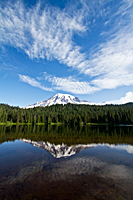
The day had a great start with sunrise at Reflection Lake![]() .
We were shocked to discover we were the only photographers there.
It was a totally bald sky, but it was still shocking that there wasn't anyone else shooting there.
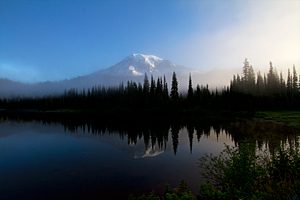
Our images were destined for the recycle bin, when the fog started flowing over the saddle
from Stevens Canyon and into the basin holding Reflection Lake. At first it was a gossamer veil
floating in front of the mountain, but it soon filled the entire basin and blocked any view of Mt. Rainier.
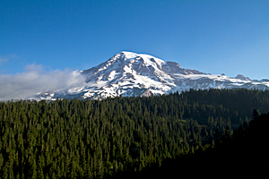
After we lost hope that Mt. Rainier would re-appear, we drove to Inspiration Point
.
We were shocked to discover we were the only photographers there.
It was a totally bald sky, but it was still shocking that there wasn't anyone else shooting there.
Our images were destined for the recycle bin, when the fog started flowing over the saddle
from Stevens Canyon and into the basin holding Reflection Lake. At first it was a gossamer veil
floating in front of the mountain, but it soon filled the entire basin and blocked any view of Mt. Rainier.
After we lost hope that Mt. Rainier would re-appear, we drove to Inspiration Point![]() and
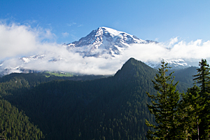
Ricksecker Point
and
Ricksecker Point![]() to shoot
Mt. Rainier in the early morning light. Inspiration Point is only about a mile from Reflection Lake, but the skies were absolutely clear as soon
as we left the Reflection Lake basin.
to shoot
Mt. Rainier in the early morning light. Inspiration Point is only about a mile from Reflection Lake, but the skies were absolutely clear as soon
as we left the Reflection Lake basin.
|
|
| Reflection Lake | Reflection Lake Fog |
|
|
| Inspiration Point | Ricksecker Point |
 We decided
to check out Tipsoo Lake near Chinook Pass as a sunrise location. We've been surprised by the amount of snow we've found as soon as
we move away from the roads. Most of the trails in the Paradise area are still under snow. We didn't want to get up at 3:30 a.m.,
drive all the way to Tipsoo Lake, and then discover that the lake was still covered by snow. We got as far as Reflection Lake
We decided
to check out Tipsoo Lake near Chinook Pass as a sunrise location. We've been surprised by the amount of snow we've found as soon as
we move away from the roads. Most of the trails in the Paradise area are still under snow. We didn't want to get up at 3:30 a.m.,
drive all the way to Tipsoo Lake, and then discover that the lake was still covered by snow. We got as far as Reflection Lake![]() .
The fog had cleared and the lake was a mirror. How could we possibly not stop? We watched two little boys catch trout as we photographed
on the east end of the lake where we could get closer to the shore of the lake. No matter how many times we've been to Reflection Lake and
no matter how many images we've taken, it's nearly impossible to drive by Reflection Lake without stopping. It changes minute-by-minute
with the lighting conditions and clouds, so it's never the same. It is definitely my favorite place in Mt. Rainier. I'm sure I'm not the only one.
I overhead a tour guide this morning tell his group that he wished he could just sit on the wall overlooking Reflection Lake and
let them finish the day without him.
.
The fog had cleared and the lake was a mirror. How could we possibly not stop? We watched two little boys catch trout as we photographed
on the east end of the lake where we could get closer to the shore of the lake. No matter how many times we've been to Reflection Lake and
no matter how many images we've taken, it's nearly impossible to drive by Reflection Lake without stopping. It changes minute-by-minute
with the lighting conditions and clouds, so it's never the same. It is definitely my favorite place in Mt. Rainier. I'm sure I'm not the only one.
I overhead a tour guide this morning tell his group that he wished he could just sit on the wall overlooking Reflection Lake and
let them finish the day without him.
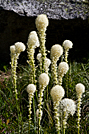
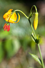
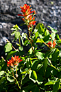
Since we were waylaid by Reflection Lake, we decided to photograph an area of bear grass we saw yesterday near the lake. It was one of the best areas of bear grass I've ever seen. As we walked around, we discovered more and more varieties of wildflowers. We photographed bear grass, lupine, western columbine, bluebells, subalpine spiraea, thimbleberry, spreading phlox, tiger lilies, Indian paintbrush, and Davidson's penstemon, as well as several wildflowers we couldn't identify. But the bear grass were clearly the stars of the show this week. The other varieties will have to wait their turn over the coming weeks.
 |
 |
|
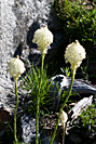 |
| Bear Grass | Tiger Lily | Indian Paintbrush | Bear Grass |
Tipsoo Lake
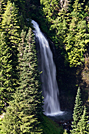 We eventually returned
to our original plan and drove to Tipsoo Lake. We stopped briefly to photograph Martha Falls from across Stevens Canyon. There is a trail
that crosses the road and then drops down to the base of the falls, but we still haven't found it. We'll had to be satisfied with using a long lens
from the road.
We eventually returned
to our original plan and drove to Tipsoo Lake. We stopped briefly to photograph Martha Falls from across Stevens Canyon. There is a trail
that crosses the road and then drops down to the base of the falls, but we still haven't found it. We'll had to be satisfied with using a long lens
from the road.
Tipsoo Lake![]() was snow-free,
but it hadn't begun to green up yet. The Naches Peak Loop trail was covered with snow on the east end,
and I'm sure there is still lots of snow in any protected areas on the west end. We had originally planned to shoot sunrise at Tipsoo Lake
and then hike the Naches Peak Trail so we would reach the reflecting tarn with morning light on Mt. Rainier. It looks we'll have
to hike this trail when we return in August.
was snow-free,
but it hadn't begun to green up yet. The Naches Peak Loop trail was covered with snow on the east end,
and I'm sure there is still lots of snow in any protected areas on the west end. We had originally planned to shoot sunrise at Tipsoo Lake
and then hike the Naches Peak Trail so we would reach the reflecting tarn with morning light on Mt. Rainier. It looks we'll have
to hike this trail when we return in August.
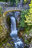
On our way back to camp, we stopped to photograph Christine and Narada Falls. Christine Falls![]() hides
below a stone bridge on the Paradise Road. The stone bridge adds character, and the narrow ravine and trees provide shade throughout the day.
It seems to work well no matter when you stop to shoot it.
hides
below a stone bridge on the Paradise Road. The stone bridge adds character, and the narrow ravine and trees provide shade throughout the day.
It seems to work well no matter when you stop to shoot it.
 |
 |
 |
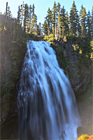
| Christine Falls | Narada Falls | Paradise River |
Narada Falls![]() was
a much bigger challenge. The trail down to the overlook is only about 1/4 mile long and provides a direct view
of the waterfall. But as you near the viewpoint, you notice the trail growing progressively wetter. And when you start shooting
in the constant mist, you quickly experience how challenging it is. I thought I had a good plan to get everything set up so my lens
would be exposed to the mist as little as possible. That lasted one shot. Every shot after the first had water spots,
no matter how many times I dried off my lens. In the end, I admitted defeat. Narada Falls had won. I'll have to try to shoot it again.
Carol chose to shoot the falls from a dry spot and gave up trying to include the bottom of the falls in her pictures.
was
a much bigger challenge. The trail down to the overlook is only about 1/4 mile long and provides a direct view
of the waterfall. But as you near the viewpoint, you notice the trail growing progressively wetter. And when you start shooting
in the constant mist, you quickly experience how challenging it is. I thought I had a good plan to get everything set up so my lens
would be exposed to the mist as little as possible. That lasted one shot. Every shot after the first had water spots,
no matter how many times I dried off my lens. In the end, I admitted defeat. Narada Falls had won. I'll have to try to shoot it again.
Carol chose to shoot the falls from a dry spot and gave up trying to include the bottom of the falls in her pictures.
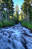
The one thing that made up for the challenge of Narada Falls was the section of the Paradise River just above the falls. We photographed from the bridge, stayed dry, and got some good shots. A trail links several falls on this stream, including Paradise Falls, Narada Falls, and Madcap Falls. If I could ever arrange transportation, I'd love to hike down this stream to shoot all the waterfalls and cascades. It would be amazing!