

It was another beautiful day in the Olympics. There wasn't a cloud in the sky when we woke up. After last night's late hours, we decided to make today a morning of waterfalls and then drive to Cape Flattery for sunset.
Marymere Falls
 Our first stop
was Marymere Falls
Our first stop
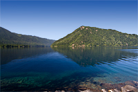
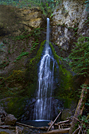
was Marymere Falls![]() near Lake Crescent. Glaciers carved a deep crescent-shaped basin between timber-covered ridges for Lake Crescent.
The lake transitions from an emerald green at the shore to a deep rich blue within a few feet of shore. The color reminds me of Crater Lake.
near Lake Crescent. Glaciers carved a deep crescent-shaped basin between timber-covered ridges for Lake Crescent.
The lake transitions from an emerald green at the shore to a deep rich blue within a few feet of shore. The color reminds me of Crater Lake.
It was only a short walk to Marymere Falls through an old-growth forest. It wasn't the Hoh River Valley, but sword ferns covered the ground and the trees were huge. There was no secondary forest layer, so the view to the top of the trees was unobstructed. That made the trees seem even taller.
We reached Marymere Falls about 11:00, just as the sun peaked over the trees directly above the falls. We couldn't have planned to be there at a worse time. We tried for about 45 minutes to get some decent shots, but in the end, we cut our losses and started back down the hill to the Explorer. We ate lunch in the picnic area by the Ranger Station, and decided we'd better skip Sol Duc Falls for today and return to camp. It was going to be a long, slow drive to Cape Flattery.
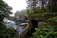
Cape Flattery
It was only about 60 miles to Cape Flattery![]() on Scenic Byway 112.
It certainly earned its designation as a scenic byway as it paralleled
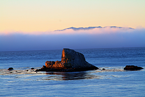
the Straits of Juan de Fuca. Occasionally, we had open glimpses of the strait and the fog bank that floated above the water. Mostly, we had curves.
Hundreds and hundreds of curves that made our 60-mile drive into a two-hour tour. We barely made it to Washburn Store to buy our recreational
passes from the Makah Nation before 5:00. As we approached Neah Bay, we saw the fog blowing in from the west through the trees lining the
ridges above town. That wasn't a promising sign. The road from Neah Bay to Cape Flattery was wide and smooth as it snaked its way
to Cape Flattery and the parking lot. It was hard to believe that this wasn't National Park land and development. The Makah Nation
did a great job of developing the area and the trail down to Cape Flattery. I had read old accounts of the muddy trail and the "pain"
required to reach the most northwest point in the United States. Now, a combination of an upgraded trail and boardwalks made it an easy,
1.5-mile roundtrip hike. The grade was good and the trail was well-maintained, often with handrails in trickier locations.
on Scenic Byway 112.
It certainly earned its designation as a scenic byway as it paralleled
the Straits of Juan de Fuca. Occasionally, we had open glimpses of the strait and the fog bank that floated above the water. Mostly, we had curves.
Hundreds and hundreds of curves that made our 60-mile drive into a two-hour tour. We barely made it to Washburn Store to buy our recreational
passes from the Makah Nation before 5:00. As we approached Neah Bay, we saw the fog blowing in from the west through the trees lining the
ridges above town. That wasn't a promising sign. The road from Neah Bay to Cape Flattery was wide and smooth as it snaked its way
to Cape Flattery and the parking lot. It was hard to believe that this wasn't National Park land and development. The Makah Nation
did a great job of developing the area and the trail down to Cape Flattery. I had read old accounts of the muddy trail and the "pain"
required to reach the most northwest point in the United States. Now, a combination of an upgraded trail and boardwalks made it an easy,
1.5-mile roundtrip hike. The grade was good and the trail was well-maintained, often with handrails in trickier locations.
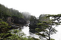
 We turned off the main trail
at the first junction to shoot from a platform overlooking a side cove. The fog nearly obstructed everything. We could see the closest islands
in the cove, but the sky and any formations farther out were nothing but gray. The fog continued to blow in and out as we stood on the platform,
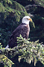
but never cleared. We moved over to a new angle to improve our view of the cove when I looked up and saw a bald eagle perched in a tree
across the cove. He was over a 100 yards away, but he made the hike worthwhile. I was hoping to catch him flying, but he took off
while we were adjusting our equipment. He evidently flew deeper into the cove, because just as we left, he and another bald eagle flew toward the open ocean.
We turned off the main trail
at the first junction to shoot from a platform overlooking a side cove. The fog nearly obstructed everything. We could see the closest islands
in the cove, but the sky and any formations farther out were nothing but gray. The fog continued to blow in and out as we stood on the platform,
but never cleared. We moved over to a new angle to improve our view of the cove when I looked up and saw a bald eagle perched in a tree
across the cove. He was over a 100 yards away, but he made the hike worthwhile. I was hoping to catch him flying, but he took off
while we were adjusting our equipment. He evidently flew deeper into the cove, because just as we left, he and another bald eagle flew toward the open ocean.
We continued down the boardwalk to two additional platforms. The final one required a short climb up a 3-rung ladder. From there, we were within a foot of falling off the continent. We could go no farther west. We heard the fog horn on Tatoosh Island in the distance, but the fog hid any evidence of the island. The fog continued to get thicker, so we packed up our gear and joined a family from Graham, Washington, as they hiked back up the hill to the parking area. The three generations of the family seemed to be having a great time, and they made the walk go faster for everyone.
|

|
|
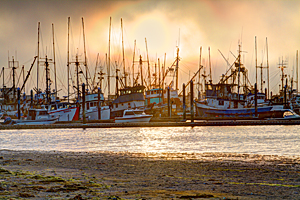
We stopped to shoot the fishing boats in the Neah Bay harbor as the sun tried to break through the fog just before sunset. It was a very interesting scene, but I'm not sure how well I handled the huge contrast in lighting between the setting sun and the dark waters of the harbor. We made a few more stops to shoot along the Straits of Juan de Fuca, and finally reached camp about 10:30. It was another late night, and we still hadn't eaten dinner. Sunrise is going to arrive awfully early tomorrow.
|
|
| Neah Bay Harbor | Straits of Juan de Fuca Fog Bank |