

The day started out overcast and gray, so I skipped sunrise and crawled back into bed. When we finally got up at 10:00, the skies had cleared, and the sun was shining.
Our first task was to empty our tanks and re-fill our water supply at the dump station. We normally last 4 days if we're dry camping and can sometimes stretch it to 5. We knew we couldn't stretch it to 8, and we didn't want to have to use the dump station on a weekend with a full campground. Leaving our campsite also forced us to re-level the motorhome in our site. We adjusted the positioning in the site slightly and used wood to raise up one side of the motorhome to make it easier to level.
Upper Lakes Trail Hike
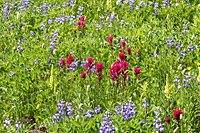
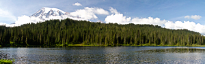
After lunch, we drove over to Reflection Lake![]() and hiked the Upper Lakes Trail,
which is known for its wildflower gardens. Most of the early hike was through coniferous forest with small meadows scattered in for color. A
trail junction at the top of the ridge gave us two choices, but both choices led to Paradise. One choice went to the High Lakes Trail while the other went to the Lakes Trail.
How is that for confusing? We picked the wrong choice and continued straight ahead. However, when it started dropping instead of climbing,
we decided something had to be wrong. We returned to the junction and took the High Lakes Trail this time and headed east. The trail was a bit disappointing
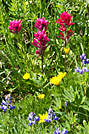
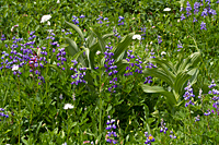
until we reached the halfway point crossing the ridge above Reflection Lake. A huge meadow opened up with flowers all the way up the ridge.
We assumed the wildflowers created a wonderful foreground for a shot of Mt. Rainier, but since the mountain was in hiding this afternoon
we don't know for sure. I concentrated on the view looking north, but Carol liked the view across a smaller meadow that looked out on the Tatoosh Range.
The trail returned to mostly forest as we continued toward Mazama Ridge. When we reached the junction with the Lakes Trail (we were on the
Upper Lakes Trail), we turned east and started down a series of steps to Artist Pool and Faraway Rock. Faraway Rock
and hiked the Upper Lakes Trail,
which is known for its wildflower gardens. Most of the early hike was through coniferous forest with small meadows scattered in for color. A
trail junction at the top of the ridge gave us two choices, but both choices led to Paradise. One choice went to the High Lakes Trail while the other went to the Lakes Trail.
How is that for confusing? We picked the wrong choice and continued straight ahead. However, when it started dropping instead of climbing,
we decided something had to be wrong. We returned to the junction and took the High Lakes Trail this time and headed east. The trail was a bit disappointing
until we reached the halfway point crossing the ridge above Reflection Lake. A huge meadow opened up with flowers all the way up the ridge.
We assumed the wildflowers created a wonderful foreground for a shot of Mt. Rainier, but since the mountain was in hiding this afternoon
we don't know for sure. I concentrated on the view looking north, but Carol liked the view across a smaller meadow that looked out on the Tatoosh Range.
The trail returned to mostly forest as we continued toward Mazama Ridge. When we reached the junction with the Lakes Trail (we were on the
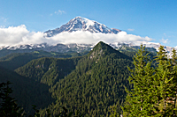
Upper Lakes Trail), we turned east and started down a series of steps to Artist Pool and Faraway Rock. Faraway Rock![]() is a cliff with a
dramatic view of Stevens Canyon to the left and the Tatoosh Range to the right. The next 3/4 of a mile was nearly all widely-spaced steps as we dropped down to Louise Lake.
I would hate to start the Upper Lakes loop from this side
and have to climb all those steps. It was bad enough going down the steps. Going up them would be an awful way to start a hike.
is a cliff with a
dramatic view of Stevens Canyon to the left and the Tatoosh Range to the right. The next 3/4 of a mile was nearly all widely-spaced steps as we dropped down to Louise Lake.
I would hate to start the Upper Lakes loop from this side
and have to climb all those steps. It was bad enough going down the steps. Going up them would be an awful way to start a hike.
 |
 |
|
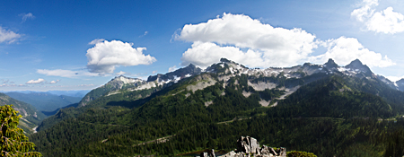 |
| Tatoosh Range |
We couldn't leave without shooting Reflection Lake. The blue skies and floating cumulus clouds drew us in again. The lighting and mood at Reflection Lake changes throughout the day, so we always find an excuse to shoot here.
 |
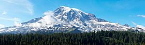 |
 We stopped at Ricksecker Point
![]() on the way back to camp.
The side lighting accentuated the ridges on Rainier and the depth of the Nisqually Valley.
The clouds created a fluffy white wreath with only the peak floating above the clouds.
on the way back to camp.
The side lighting accentuated the ridges on Rainier and the depth of the Nisqually Valley.
The clouds created a fluffy white wreath with only the peak floating above the clouds.
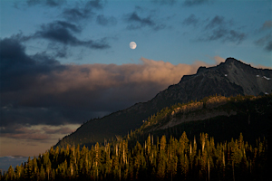
We relaxed in camp for a couple hours before we searched for a place to shoot moonrise. Tonight was the beginning of the August supermoon. It was supposed to be the largest moon of the year, and tonight moonrise was at sunset. Without Internet access, we were without all our tools for determining exactly where the moon will rise on any given date. My iPhone has an app, but I wasn't sure how accurate it was. All we knew for sure was that the moon would rise somewhere over Stevens Canyon around sunset tonight.
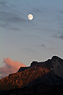 We drove the road
toward Reflection Lake and Stevens Canyon and checked the peaks of the Tatoosh Range in hopes that the moon would come up near one of the peaks.
We passed Reflection Lake and most of the main peaks of the Tatoosh Range but saw no moon. Then we turned a corner as we started dropping
down toward Stevens Canyon and saw a guy shooting the moonrise over Stevens Peak. We turned around, found a place to park, and began shooting the moonrise.
The moon was already far above the horizon, so we missed the sense of a "super" moon, but we watched it peek in and out of the clouds
as it crossed over the Stevens Peak. The trees and peak still had some warm sunset light on them, so it wasn't a complete bust.
We drove the road
toward Reflection Lake and Stevens Canyon and checked the peaks of the Tatoosh Range in hopes that the moon would come up near one of the peaks.
We passed Reflection Lake and most of the main peaks of the Tatoosh Range but saw no moon. Then we turned a corner as we started dropping
down toward Stevens Canyon and saw a guy shooting the moonrise over Stevens Peak. We turned around, found a place to park, and began shooting the moonrise.
The moon was already far above the horizon, so we missed the sense of a "super" moon, but we watched it peek in and out of the clouds
as it crossed over the Stevens Peak. The trees and peak still had some warm sunset light on them, so it wasn't a complete bust.
We drove over to Inspiration Point to watch the last sunlight on the Nisqually Valley and the clouds crossing the face of Mt. Rainier. There was a little sunset color to the west of Mt. Rainier, but it couldn't quite stretch far enough to reach the face of the mountain. We didn't totally miss the supermoon, but we certainly didn't capture it either. We probably should have gone to Sunrise Point for moonrise.