

Today was another gorgeous day at Capitol Reef. It just doesn't get any better than this.
We got an early start on our hike to Hickman Bridge,![]() so we could get early-morning light warming the sandstone bridge.
Even though we started long before the sun hit the canyon floor,
the best light was already gone by the time we reached the bridge.
It looks like you need to be there within a few minutes of sunrise
to get the best light. The hike to Hickman Bridge was only a
mile each way, and this time it seemed easier than last time.
It was probably the nice, cool weather. We met Bill who is a
pilot at Southwest Airlines and shared stories with him as we
photographed the bridge.
so we could get early-morning light warming the sandstone bridge.
Even though we started long before the sun hit the canyon floor,
the best light was already gone by the time we reached the bridge.
It looks like you need to be there within a few minutes of sunrise
to get the best light. The hike to Hickman Bridge was only a
mile each way, and this time it seemed easier than last time.
It was probably the nice, cool weather. We met Bill who is a
pilot at Southwest Airlines and shared stories with him as we
photographed the bridge.
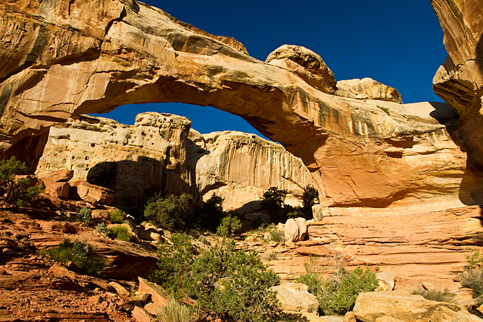
After we finished shooting the front side, we hiked
under the bridge and shot on the back side. It wasn't as well-lit, but there was enough light reflecting along
the sides of the fins that it was still an interesting shot.
We continued down the trail to an overlook of the Fremont River
and the orchards planted by the early Mormon settlers in Fruita.
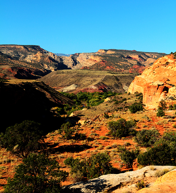
One of the mind-boggling things about the hike is the sandstone plateau the trail crosses to ascend from the river canyon to the fin that includes the natural bridge. The plateau is sparsely covered with vegetation so you can't help but notice the round black rocks about the size of a basketball. These black rocks are actually volcanic bombs that were launched during the eruption around Boulder Mountain. Can you imagine standing on the plateau and hearing a horrendous explosion in the distance before you were bombarded with these black cannonballs? I'm sure you'd hear them whistling through the air on all sides of you before they struck. From the fairly even dispersal, I don't think there would be any escape unless you could get out-of-range or behind a taller ridge.
When we returned to camp, we did some last-minute clean-up and started for Bryce Canyon. After driving over Boulder Mountain in the Explorer on our road trip day, we decided take the alternate route down through the valley of the Sevier River. The road isn't as dramatic as the one over Boulder Mountain (nor as steep and scary in places), but it's still a nice drive. It follows valleys between tall ridges covered with aspens at the top. The valleys are mostly ranch land, with areas where the Sevier meanders back and forth between the angus cattle.
The only sad part of the trip was an accident we saw in Red Canyon just before we reached Bryce. A car had just overturned and the emergency responders were trying to get the occupants out. The car was still on its roof and it looked bad. I'm not sure how you can have a single-car rollover accident on a winding slow road, but it happened.
By 4:30, we were all set up and enjoying the comforts of electrical hookups, cell phone service and the Internet. Carol wasn't very enthused about shooting sunset over the canyon, so we made dinner, watched a movie, and got caught up on all our email and Internet stuff.
We toddled off to bed and thought our night was over. Then at 1:30 the carbon monoxide monitor brought all thoughts of sleeping to an abrupt halt. We checked everything out, reset the monitor and went back to bed. Ten minutes later, it went off again. We still couldn't find anything wrong, so we reset it again. The next time it went off, we unscrewed the unit and checked to see if it could have batteries that needed to be replaced. Nope, no batteries. After about the fifth time, we cranked up all the vents to let in fresh air and waited until the carbon monoxide light went green. Then we put the heavy comforter on the bed (it's below freezing outside) and went to sleep with the vents open. The carbon monoxide monitor let us sleep through the rest of the night, but it was a very long night.
Needless to say, the motorhome was an ice box when we woke up for sunrise.