

Today was the first day of my very brief vacation. Carol and I are celebrating our 15th anniversary together by going to Crater Lake. We left the motorhome in Ashland and drove the Explorer. On the way to Crater Lake, we stopped at two covered bridges and 3 waterfalls. This is where all those long hours of preparation pay off. All the waterfalls and covered bridges have been saved to the GPS, so it's relatively easy to plan the routes with lots of good stops.
When Carol got into the Explorer, the support handle above the door pulled completely out. I had to get out our tripod tools and re-fasten it. My poor Explorer is starting to show its age more and more. First it was the back window hinges and now the support handle. There could be a trend here.
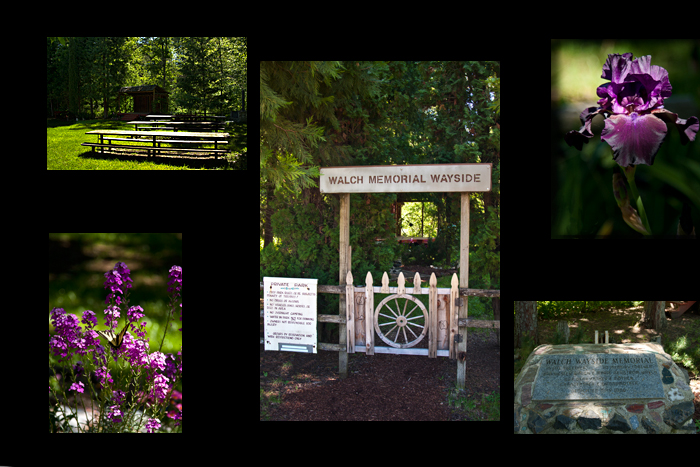
The first stop was Lost Creek Covered Bridge.![]() For awhile, I thought we were the ones that were lost. The GPS took us
up a narrow back highway into some gorgeously green hills
above Ashland. Then, it told us to leave the highway and
go on this NARROW but paved Forest Service Road. The forest
road took us over the mountain and then down through a series
of valleys until we dropped all the way back down to the
bottom. About 3 miles later, we were at Lost Creek Covered
Bridge. We would have never chosen that route using maps,
but it was a very interesting drive. The covered bridge was
pretty ordinary, but the park next to it wasn't. It was a
private park created by a landowner who created something
pretty special. There were a couple rules, but he/she provided
free access to anyone who wanted to wander in. This sounds
redundant, but it was manicured like a park. There was a
small stage, lots of flowers, gorgeous rhododendrons, some
interesting old buildings, bearded iris, picnic tables, and
a stream. John and Marie Walch were buried in a small plot
near the stream. "Idyllic" pretty much sums up
the park by the stream.
For awhile, I thought we were the ones that were lost. The GPS took us
up a narrow back highway into some gorgeously green hills
above Ashland. Then, it told us to leave the highway and
go on this NARROW but paved Forest Service Road. The forest
road took us over the mountain and then down through a series
of valleys until we dropped all the way back down to the
bottom. About 3 miles later, we were at Lost Creek Covered
Bridge. We would have never chosen that route using maps,
but it was a very interesting drive. The covered bridge was
pretty ordinary, but the park next to it wasn't. It was a
private park created by a landowner who created something
pretty special. There were a couple rules, but he/she provided
free access to anyone who wanted to wander in. This sounds
redundant, but it was manicured like a park. There was a
small stage, lots of flowers, gorgeous rhododendrons, some
interesting old buildings, bearded iris, picnic tables, and
a stream. John and Marie Walch were buried in a small plot
near the stream. "Idyllic" pretty much sums up
the park by the stream.
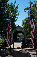
The second stop was Antelope Creek Covered Bridge![]() in Eagle Point. It was very patriotic with flags flying all around. The high school let out for the final day of school as we arrived.
Most of the students had to pass over the bridge to get home, so it made for an very entertaining stop. We also stopped
at the Butte Creek Mill where they still use stream power to grind grain. I think they grind about every type of grain
or seed they can think of.
in Eagle Point. It was very patriotic with flags flying all around. The high school let out for the final day of school as we arrived.
Most of the students had to pass over the bridge to get home, so it made for an very entertaining stop. We also stopped
at the Butte Creek Mill where they still use stream power to grind grain. I think they grind about every type of grain
or seed they can think of.
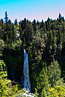
Our next stops were all in the Prospect area. Mill Creek and Barr Creek Falls![]() are very close together in an area developed by the timber owner for visitor recreation. It wasn't fancy,
but they did a good job of maintaining the trails. Both falls were similar as they dropped over basaltic cliffs.
This will be a theme as we shoot waterfalls for the next couple weeks. Mill Creek Falls drops 175 feet through a tunnel of trees
across the valley from the viewpoint. Barr Creek Falls is just downstream and drops 240 feet.
are very close together in an area developed by the timber owner for visitor recreation. It wasn't fancy,
but they did a good job of maintaining the trails. Both falls were similar as they dropped over basaltic cliffs.
This will be a theme as we shoot waterfalls for the next couple weeks. Mill Creek Falls drops 175 feet through a tunnel of trees
across the valley from the viewpoint. Barr Creek Falls is just downstream and drops 240 feet.
|
 |
 |
| Antelope Creek Bridge | Mill Creek Falls | Burr Creek Falls |
Prospect Falls is much more like a cascade. The most interesting thing about it is the cabin right next to it. The owners have built a patio next to the main drop in the cascades. I can imagine them sitting out on the patio sipping wine and watching the sunset over the cascades. Must be nice.
Our final stop before Crater Lake was Natural Bridge on the Rogue River. Jackie had mentioned something about it last night, so we thought we would check it out. The river flows along like normal and then disappears into a lava tube before it returns to the river downstream. Because the river level was so high, we couldn't really get the full impact of the natural bridge. The lava tube couldn't handle the volume and the river still spilled over the top. Looking at where the water returned to the river was very cool. The river bubbled up from the lava tube under the opposite shore. It looked like the outlet pipe at a giant dam.
On to Crater Lake. The road to Crater Lake was wide and built for lots of traffic. On a week day, there was almost no traffic, so we got to the edge of the park in no time. It was sunny and warm. But as we climbed higher, we began seeing more and more snow. The final 6 or 8 miles had 10-foot snow banks on both sides of the road. Places like Godfrey Glen were no where to be seen. There was so much snow at Rim Village that I didn't recognize it. The front parking lot was completely buried in snow. In fact, the snow drift reached halfway up the roof of the general store, a 3-story building.
The Rim Road at Crater Lake was only open about a mile to Discovery Point, so we decided to go out and photograph before we checked in at the lodge. The parking area was cleared and there was enough foot traffic to climb up on the snow drifts to see the lake. Crater Lake was beautiful in the snow, but there are only so many pictures of Wizard Island you can take from the same spot.
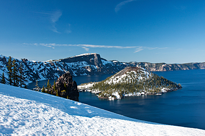
We drove over to Crater Lake Lodge and checked in. The parking lot still had 10 foot drifts all around the edge. It made our Explorer look small. We have a room with a great view of Crater Lake. In fact, we decided the place with the best view of the lake may be the snow drift just behind Crater Lake Lodge.
Because we checked in late in the afternoon, 9:45 was the earliest available dinner reservation. By the time we got unpacked and cleaned up, we had to hustle to make that 9:45 reservation. We had a very nice anniversary dinner punctuated by the full moon rise through a window in the dining room.