

 Today was a great day! Since we had shot the South Falls area yesterday, we decided to leave Silver Falls and explore some new areas.
I have seen photos of Proxy Falls for years and have always wanted to photograph them. Today would be the day.
Today was a great day! Since we had shot the South Falls area yesterday, we decided to leave Silver Falls and explore some new areas.
I have seen photos of Proxy Falls for years and have always wanted to photograph them. Today would be the day.
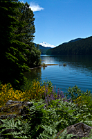
We drove Highway 22 East toward Bend. It didn't take long to understand why it had a scenic byway designation. The first part of the road paralleled the Santiam River until we reached the dams of the Detroit Lake area. As we drove along the lake, we saw snow-covered Mt. Jefferson just above the trees surrounding the lake. We pulled over and photographed wildflowers in the foreground, the lake in the mid distance, and Mt. Jefferson peeking over the forest. We were shooting toward the sun, but it was still a cool shot.
Just a couple miles farther up the road, we discovered the Detroit Lake State Park Campground. When we checked for cell service, we found that Verizon had a strong signal. That was great news, because we didn't get any signal at Silver Falls. I need cell service so I can work tomorrow. Now, I can have an "office" with the view of the lake and the surrounding mountains. That's my idea of an office. We made reservations for 3 nights and continued on our way toward Proxy Falls.
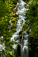
Our next stop was Sahalie Falls.![]() It was on the way to Proxy Falls and right next to the highway, or we might have skipped it. That would have been a mistake.
Sahalie Falls is on the McKenzie River, and it's one of the most beautiful rivers I've ever seen. We dutifully photographed the falls,
and then hiked down the trail along the river. The McKenzie River has this amazing shade of emerald green, but it wasn't milky
like the rivers that carry glacial flour. The water was crystal clear, even running so full from snow melt.
The river is in a tight channel around the falls with lush bushes and trees lining it on both sides. The same characteristics
that make it feel intimate and magical also make it very difficult to photograph. I would love to have two or three more days
to photograph along this upper stretch of the river.
It was on the way to Proxy Falls and right next to the highway, or we might have skipped it. That would have been a mistake.
Sahalie Falls is on the McKenzie River, and it's one of the most beautiful rivers I've ever seen. We dutifully photographed the falls,
and then hiked down the trail along the river. The McKenzie River has this amazing shade of emerald green, but it wasn't milky
like the rivers that carry glacial flour. The water was crystal clear, even running so full from snow melt.
The river is in a tight channel around the falls with lush bushes and trees lining it on both sides. The same characteristics
that make it feel intimate and magical also make it very difficult to photograph. I would love to have two or three more days
to photograph along this upper stretch of the river.
As we continued on, little wildflower gardens started popping up along the road. In one area, they were foxgloves. Next, it was lupine followed by larkspur. Then came red columbines. We didn't have time to photograph any of the wildflowers today, but we hope to change that after work tomorrow.
The highway paralleled the McKenzie River until we made the turn to climb up toward McKenzie Pass and Proxy Falls.
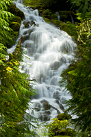
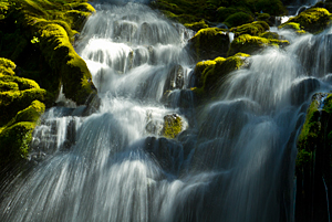
The short hike to Proxy Falls![]() crossed a volcanic flow and then dropped into a canyon that led to the falls. Proxy Falls was amazing, but we had to work hard for the shots.
We shot from a small rocky ledge off to the side of the falls and then climbed up the ridge behind the pool for a second angle.
What we missed was the developed viewing area. By the time we had shot from the base of the falls, we needed to hustle to return to Silver Falls,
pick up the motorhome, and move to Detroit Lake Campground. We didn't have time to look for the viewing platform.
crossed a volcanic flow and then dropped into a canyon that led to the falls. Proxy Falls was amazing, but we had to work hard for the shots.
We shot from a small rocky ledge off to the side of the falls and then climbed up the ridge behind the pool for a second angle.
What we missed was the developed viewing area. By the time we had shot from the base of the falls, we needed to hustle to return to Silver Falls,
pick up the motorhome, and move to Detroit Lake Campground. We didn't have time to look for the viewing platform.
|
|
 |
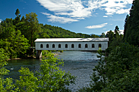 Our final stop was a couple of very quick shots of Goodpasture Covered Bridge,
which crossed the McKenzie River.
Our final stop was a couple of very quick shots of Goodpasture Covered Bridge,
which crossed the McKenzie River.![]() Unlike most of the covered bridges we have seen, it was painted white and had windows
along the length of the bridge.
Unlike most of the covered bridges we have seen, it was painted white and had windows
along the length of the bridge.
Then, we rushed back to Silver Falls, packed up the motorhome, connected the Explorer, and drove to Detroit Lake. We arrived about 9:00 and barely got everything set up before dark. It turned out to be a long day, but it was a great day. We drove a total of about 300 miles and nearly all of it was gorgeous. We saw Christmas tree farms, waterfalls, snow-frosted mountains, lakes, wildflowers, rushing rivers, and a covered bridge.