

Back to work. Today's "office view" was of Detroit Lake, fir trees all around the lake, and mountains in the background. For entertainment, there was a mallard hen and her ducklings, and two Canadian geese and their young. The ducklings were very small, but the Canadian geese young looked like they would soon be flying.
Carol spent the day with Nancy Hallin. Nancy used to live in San Diego and worked with Carol as the manager of their pottery business. Carol and Nancy explored the area around Detroit Lake and were entertained during lunch by the families of Canadian geese.
After work, it was time to jump in the Explorer and shoot along the Santiam Highway. Our first stop was Tumble Creek. It looked promising when we were driving on the highway on Tuesday, so we decided to check it out. It even had a small parking area. The name "Tumble Creek" was certainly appropriate. The entire lower portion of the stream was a series of cascades over the boulders in the bottom of the creek. As we hiked on the trail above the stream, we began seeing more and more wildflowers. There were red columbines, yellow native iris, white thimbleberries, white trillium, and a host of flowers that I couldn't identify. The bracken ferns were wearing their new green luster as they lined the trail. We didn't walk very far, but every new turn was a reminder that it was spring in the mountains.
Nancy had to leave us when we finished along Tumble Creek, but Carol enjoyed spending the day with her.
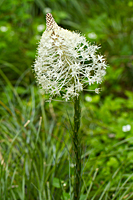
Our main goal of the evening was to return to the McKenzie River near Sahalie Falls. We started at about 2,000 feet in elevation and climbed to about 4,000 feet by the time we reached the falls area. As we climbed, the plants changed. The biggest surprise was the patches of bear grass. I've never seen bear grass except at the higher elevations in the Rockies or areas like Mt. Rainier. I didn't expect to find them in the central Cascades, and certainly not in June.
|
|
|
|
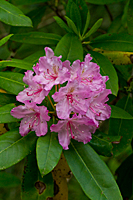
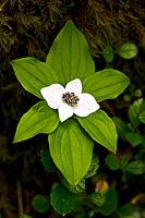
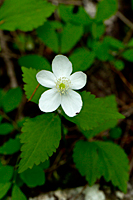
| Rhododendron | Bunchberry | ? | Bear Grass |
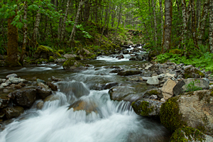
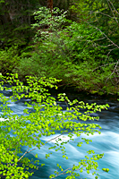 By the time we reached the McKenzie River, it was nearly 7:00. We discovered the McKenzie River Trail
![]() near the highway bridge crossing the river. We hiked down river to find a place to photograph the river in the tight confines
of the canyon. And then we found the bridge. A giant log crossed the river with two handrails attached.
It was very tight quarters with a tripod, but it provided a unique view of the river.
near the highway bridge crossing the river. We hiked down river to find a place to photograph the river in the tight confines
of the canyon. And then we found the bridge. A giant log crossed the river with two handrails attached.
It was very tight quarters with a tripod, but it provided a unique view of the river.
As I was finishing up from the bridge, I noticed the dogwood tree in bloom across the river. There were vine maples in the foreground stretching out over the river with the dogwood tree in the background. A slow shutter speed to blur the river rapids made a classic shot. The only problem was that the vine maple leaves wouldn't stop moving in the breeze. After fighting with the depth of field and the vine maples, I decided to try another angle downstream. The scene still had the same elements as the previous location, but the vine maples were a little more cooperative.
I stopped shooting when my compact flash card was full. I figured that was a "sign." I kept thinking all the way back to the Explorer what a great place this would be for bears. They would just be starting their evening foraging about now, and here we were right in prime bear country.
When we got back to the Explorer, I put a new compact flash card in my camera and walked over to the highway bridge for one last shot of the McKenzie River. It was getting dark, but there was just enough light to shoot one last series.
It was great having another chance to shoot the McKenzie River, but it was a long drive back to camp in the dark. By the time we got back, it was 10:30, and I was too tired to care about dinner. I downloaded my images and went to bed. I have to work tomorrow morning.