

Today was a great day! An image on a photographer website inspired me to look for a group of cascades just below Tuolumne Meadows. After doing some research, the cascades seemed to be just below Pothole Dome on the west end of Tuolumne Meadows. Our goal for today was to find those cascades.
On our way to Tuolumne Meadows, we noticed that Tenaya Lake was unusually calm. We decided to make a quick stop and look for reflections. Although the lake was like glass, the view from the east end of the lake isn't as dynamic as the west end. Even the cumulus clouds and reflections of Polly Dome couldn't make it a good shot. I think we enjoyed watching all the British tourists along the beach more than the photographing.
When we reached Pothole Dome, we hiked around the bottom edge of the dome and the western fringe of Tuolumne Meadows.
As we shot some images of the meadow behind the meandering river, we heard the cascades in the distance. After one final
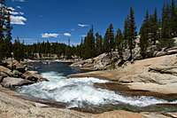
curve and a short climb over a ridge, we saw the cascades we were hunting for![]() (37 degrees 53' 12.4"N 119 degrees 23' 17.9"W). The Tuolumne River changed from a deep,
green, lazy river to white water in a few feet. As we looked down river from the ridge, everything was solid granite
below us. The granite looks like frozen rock that once flowed from north-to-south across the river. Just below us,
the middle finger of the granite hand nearly reached the other side and forced the river through a four-foot gap before
it reached the pool below. Standing on a granite pinkie stretching into the pool below was a woman fishing. It was
a remarkable scene, but it was only the beginning.
(37 degrees 53' 12.4"N 119 degrees 23' 17.9"W). The Tuolumne River changed from a deep,
green, lazy river to white water in a few feet. As we looked down river from the ridge, everything was solid granite
below us. The granite looks like frozen rock that once flowed from north-to-south across the river. Just below us,
the middle finger of the granite hand nearly reached the other side and forced the river through a four-foot gap before
it reached the pool below. Standing on a granite pinkie stretching into the pool below was a woman fishing. It was
a remarkable scene, but it was only the beginning.
|
|
 |
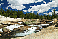
Below the pool, we turned the corner and saw the next set of granite fingers that would break the river into several channels. The river bounced and churned as it continued its downward race to the pool at the bottom of this set of steps. The river followed the depressions in the granite and bounced from one rock to the next until it jumped two final hurdles and entered a large pool.
One of the advantages of having the entire area as a huge slab of granite was that it was very easy walking down beside the river. As we looked back up river from the second pool, the river and trees focused our eyes on the two cascade steps and Unicorn Peak on the Sierra Crest above the river. Everything from the riverlet at our feet to the mountains in the background added to the scene.
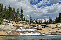
From the second pool, the river continued on its way to the Grand Canyon of the Tuolumne by crossing a wide, flat expanse of granite. It was as if it needed a stretch to rest a bit before it began its next big drop. As dramatic as the scene was, I can only imagine what it must look like at the height of the snow melt in Tuolumne Meadows. It must be solid whitewater for miles.
We finally decided it was time to head back up the river and back to the Explorer. This was one of those times it would have been very easy to go from one great area to the next until we found ourselves miles from the parking lot. It seemed like each new turn in the river was better than the last.
As we approached the final ridge before returning to Tuolumne Meadows, we decided to try a shortcut trail on the back side of the ridge. A fisherman's trail was pretty obvious, so we took a chance that we could cut off about half the distance back to the Explorer. The goal was to go behind the ridge and then behind Pothole Dome and meet up with the trail from the parking lot. The trail was nice and flat and easy to follow for the first 1/4 mile before it faded into oblivion. We saw a well-traveled trail just below us, so we veered a bit to the left and took it down the hill.
 As we looked through the trees ahead, we saw the Tuolumne River and realized we weren't where we thought we should be.
In fact, we had basically hiked along a level area between the ridge and Pothole Dome and were back on the main trail
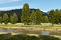
for Pothole Dome. A herd of deer welcomed us to Tuolumne Meadows and wandered back across the river to feed on the
other side. As we walked along the edge of the meadow, there were deer everywhere. It was about 90 minutes before
sunset, so it should be no surprise that there were deer here. It was the number of deer that was surprising. We saw
more deer in one evening than we had seen in all of our other trips to this area put together.
As we looked through the trees ahead, we saw the Tuolumne River and realized we weren't where we thought we should be.
In fact, we had basically hiked along a level area between the ridge and Pothole Dome and were back on the main trail
for Pothole Dome. A herd of deer welcomed us to Tuolumne Meadows and wandered back across the river to feed on the
other side. As we walked along the edge of the meadow, there were deer everywhere. It was about 90 minutes before
sunset, so it should be no surprise that there were deer here. It was the number of deer that was surprising. We saw
more deer in one evening than we had seen in all of our other trips to this area put together.
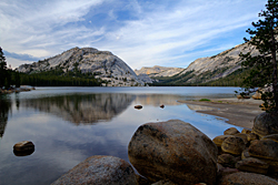 The west shore of Tenaya Lake
![]() was our choice for shooting sunset. We had completely missed Tenaya
Lake on the May trip, so we wanted to be sure to get some good shots here. After we parked and got out of the Explorer,
we knew we were in for a challenge. The mosquitoes made their presence known immediately. We decided to try shooting
anyway and took our places on the point that extends into the lake. As I was setting up my panorama head, there was a
constant buzz as a giant cloud of mosquitoes filled the area. Interestingly, they left me completely alone. I shot
for about 20 minutes before deciding to shoot in another area. Carol had already gone over to a different arm of
the lake and was shooting on her own.
was our choice for shooting sunset. We had completely missed Tenaya
Lake on the May trip, so we wanted to be sure to get some good shots here. After we parked and got out of the Explorer,
we knew we were in for a challenge. The mosquitoes made their presence known immediately. We decided to try shooting
anyway and took our places on the point that extends into the lake. As I was setting up my panorama head, there was a
constant buzz as a giant cloud of mosquitoes filled the area. Interestingly, they left me completely alone. I shot
for about 20 minutes before deciding to shoot in another area. Carol had already gone over to a different arm of
the lake and was shooting on her own.
When I reached the area with the good reflections, I quickly discovered there were NO pacifist mosquitoes over here. They made that abundantly clear immediately. It is very rare that something prevents me from getting the shots I want, but after every inch of my arms, forehead, neck, and face had been bitten, I surrendered. I packed up my gear just in time to see Carol had made the same decision, and we made a run for the Explorer. It was AWFUL! I thought I was back in Minnesota.
It still wasn't sunset, so we drove up the road to Olmstead Point. I figured the higher elevation, breeze, and lack of water should keep us safe from the mosquitoes. Carol was taking no chances and stayed in the Explorer. I set up and took a few panoramas, but it didn't look like anything was going to happen for sunset. There were high clouds over the peaks, and the sun had already dropped below the ridge. Everything below us was in shade. But it was the return of the mosquitoes that had me packing up and giving up on the sunset.
We were about 5 miles down the road when we realized we had made a MAJOR mistake. The clouds in every direction had turned pink. When we came around a long curve overlooking Yosemite Creek, the entire sky ahead of us was orange. We drove another five minutes before we could find a good turnout, but by then the sun was completely down and the best was gone. It was still impressive, but there was nothing for a foreground and the mountains had gone black. Somewhere on Glacier Point and at Tunnel View photographers were ecstatic at their luck at getting such an amazing sunset.