Our plan was to drive the Tioga Road on Saturday to get out of the Valley on the weekend, but we couldn't wait to get back up into the High Country. We decided to drive the Tioga road today to check out the conditions and then return on Saturday to shoot the best places.
 Our first stop was Olmstead Point
![]() ,
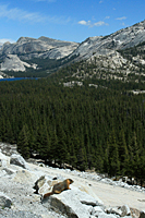
one of my favorite places in Yosemite. The view east includes Tenaya Lake, Pywiack Dome, and Mt. Conness.
The view west includes Clouds Rest and the down-canyon view of Half Dome. We normally climb the dome above Olmstead Point
for the view toward Tenaya Lake, but the sky was flat and not worth the effort. Instead, we were going to shoot pikas and marmots.
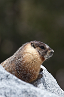
It didn't take long to find the marmots; about 1 minute. The sun was breaking through the high clouds, and the marmots couldn't
wait to start their sun bathing. We played hide-and-seek over an hour with the marmots as they crawled in and out of the voids
in the granite boulders that they call home.
,
one of my favorite places in Yosemite. The view east includes Tenaya Lake, Pywiack Dome, and Mt. Conness.
The view west includes Clouds Rest and the down-canyon view of Half Dome. We normally climb the dome above Olmstead Point
for the view toward Tenaya Lake, but the sky was flat and not worth the effort. Instead, we were going to shoot pikas and marmots.
It didn't take long to find the marmots; about 1 minute. The sun was breaking through the high clouds, and the marmots couldn't
wait to start their sun bathing. We played hide-and-seek over an hour with the marmots as they crawled in and out of the voids
in the granite boulders that they call home.
We never saw any pikas at Olmstead Point. We have always seen them here in the past, but a tour guide told us that they had moved to higher elevations. They have a very small temperature tolerance, and global warming has forced many of them out of this location.
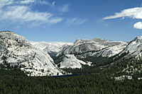
We pulled into a turnout![]() just beyond Olmstead Point for a good spot for shooting a panorama of Tenaya Lake. As soon as we pulled in, two marmots
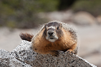
crossed the road from the dome above Olmstead Point and joined us in the turnout. One of the marmots continued down the side
of the mountain for the boulder field below, but the other marmot stopped at the curb of the road and started licking something
on the road. It took a minute, but I realized that it was licking antifreeze from the roadway. Marmots like the salty taste
and will lick the antifreeze until it kills them. I used my foot to "encourage" him to leave the antifreeze and
move away from the road. He moved a few feet away and posed on a rock to provide a perfect foreground to a picture
of Tenaya Lake, Pywiack Dome, and Mt. Conness. He was very friendly and continued to hang out with us for nearly an hour.
We had to chase him away from the antifreeze one more time, but he seemed to get the message and returned to the boulders
below the road. He certainly had no fear of humans.
just beyond Olmstead Point for a good spot for shooting a panorama of Tenaya Lake. As soon as we pulled in, two marmots
crossed the road from the dome above Olmstead Point and joined us in the turnout. One of the marmots continued down the side
of the mountain for the boulder field below, but the other marmot stopped at the curb of the road and started licking something
on the road. It took a minute, but I realized that it was licking antifreeze from the roadway. Marmots like the salty taste
and will lick the antifreeze until it kills them. I used my foot to "encourage" him to leave the antifreeze and
move away from the road. He moved a few feet away and posed on a rock to provide a perfect foreground to a picture
of Tenaya Lake, Pywiack Dome, and Mt. Conness. He was very friendly and continued to hang out with us for nearly an hour.
We had to chase him away from the antifreeze one more time, but he seemed to get the message and returned to the boulders
below the road. He certainly had no fear of humans.
 |
 |
 |
After our marmot adventure, we continued up Tioga Road to the pass. Even at Tioga Pass and Mt. Dana, the snow was only patchy. It looked more like late June or early July than May. There was still some ice on some of the tarns at the pass, but there was very little snow. We checked out the trailhead to the Gaylor Lakes basin, but it was very muddy. That hike will have to wait until June.
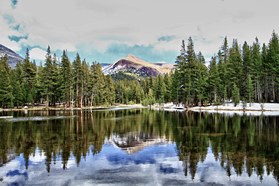
We stopped at the unnamed tarn just below Dana Meadows![]() to shoot the reflections of Mt. Dana and Mt. Gibbs. We've been shooting here for years, but the additional water
from the snow melt made this one of the best shots we've ever had here. The option to use HDR provided additional
emphasis to the reflection and added another dimension.
to shoot the reflections of Mt. Dana and Mt. Gibbs. We've been shooting here for years, but the additional water
from the snow melt made this one of the best shots we've ever had here. The option to use HDR provided additional
emphasis to the reflection and added another dimension.
We continued west to Tuolumne Meadows and Lembert Dome. We've always enjoyed the walk on the trail across the meadow and over the bridge on the Tuolumne River. The Tuolumne River is exerting its will on the plans of the Park Service. The bridge that has crossed the Tuolumne River near Soda Springs has been there since the 1930's, but the river is changing course to the south and will soon bypass the bridge unless something is done. One of the interesting things about returning to a park over a 40 year period is that we get to see it change. Mirror Lake fills to become a meadow. The river changes course at Valley View to completely change the shot toward El Capitan. Animal populations have to migrate to higher elevations if they are sensitive to the heat. The lodgepole pines continue to encroach on Tuolumne Meadow. Yosemite is constantly changing.
 As we drove back toward Tenaya Lake, we spotted a ridge to the southeast that had a cascade coming down the mountain.
It took a couple of passes, but we found a place to park so we could photograph the cascade. In the process,
I found a cool new place to shoot
As we drove back toward Tenaya Lake, we spotted a ridge to the southeast that had a cascade coming down the mountain.
It took a couple of passes, but we found a place to park so we could photograph the cascade. In the process,
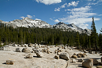
I found a cool new place to shoot![]() ( 37°51'19.80"N 119°26'22.41"W). It's a huge slab of granite
covered with perched erratics of all sizes. Although I couldn't shoot the cascade from here, there is a good view
of Tenaya Peak. It looks like you can hike down the road a short distance to see the cascade and Cathedral Peak.
I think the cascade is the outlet from Lower Cathedral Lake.
( 37°51'19.80"N 119°26'22.41"W). It's a huge slab of granite
covered with perched erratics of all sizes. Although I couldn't shoot the cascade from here, there is a good view
of Tenaya Peak. It looks like you can hike down the road a short distance to see the cascade and Cathedral Peak.
I think the cascade is the outlet from Lower Cathedral Lake.
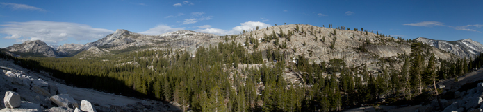
We returned to our turnout below Olmstead Point![]() to shoot panoramas as sunset approached. There were no clouds in the sky, so it was much more about practicing the
panorama technique than hoping to get great images.
to shoot panoramas as sunset approached. There were no clouds in the sky, so it was much more about practicing the
panorama technique than hoping to get great images.