

Hetch Hetchy
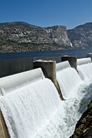
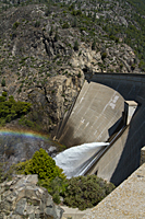
I always have mixed feelings about going to Hetch Hetchy. It is a beautiful valley; a nearly perfect twin to Yosemite Valley. But unlike Yosemite, it wasn't protected and a dam has flooded Hetch Hetchy. It was one of John Muir's greatest losses, and it remains a loss to all lovers of Yosemite. Although promises were made for the development of a wonderful recreation area for the people of California, no development was ever allowed. In fact, no one is permitted to swim or boat on the lake, and not a single facility was ever built. It's a constant reminder that if we don't protect places like Yosemite and Hetch Hetchy, there will always be those who will try to convince the people that they would be better off privatized or developed for the benefit of some large corporation. This is certainly appropriate as the House of Representatives recently passed a bill to gut the Wilderness Act of 1964, and the Senate is arguing over their version of the same legislation. In the guise of "protecting" the heritage of fishing and hunting, members of Congress are attacking the kind of legislation that gave us places like Yosemite, Grand Tetons, and Glacier National Park. If the legislation is passed, we could soon see roads built in the wilderness to "improve access for hunters and fishermen." And, oh yes, to provide easier access for harvesting timber in our wilderness areas.
Our goal for the day was to photograph Tueeulala and Wapama Falls. Neither of us had ever hiked to either of the falls, but the trail looked pretty level, and we could clearly see our destination as we stood on the dam (You can see Wapama Falls beyond the dam in the image below). It turned out that seeing the falls through most of the hike was a bit misleading. The farther we hiked, the more it seemed to be just around the corner.
 |
 |
|
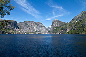
We hiked across the dam, through a tunnel, and under the shade of the oak forest along the west end of the lake. After about 1/2 mile, the trail was more exposed and the views opened up across the lake to Kolana Rock. If Wapama Falls is the Yosemite Falls of Hetch Hetchy, Kolana Rock is the El Capitan. Just as El Capitan forms one side of the Gates of Yosemite, Kolana Rock forms the west pillar of the gate up the Tuolumne River valley. There were even a few clouds peaking over the southern ridge across the lake. We've had nothing but flat blue skies nearly the whole week. That's great for hiking and enjoying a beautiful day, but it's very tough for getting good images. We're hoping for clouds at sunset tonight.
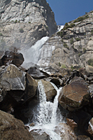
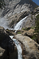
The lack of snow and early spring made Tueeulala Falls little more than a whisper. It was barely visible from the trail and was easily blown from side-to-side by the wind. After another mile, the trail dropped about a 100 feet and turned a blind corner before we got our first up-close view of Wapama Falls. It was impressive! After Falls Creek leaps over the granite cliff, it drops 1340 feet before the granite talus splits the stream into multiple channels and forms separate cascades into the lake.
By the time we reached Wapama Falls,![]() it was getting warm and the trail had been exposed for the last hour. The mist off the falls was
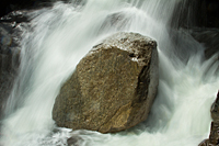
like a refreshing shower. We crossed the bridges used to span the multiple channels of the creek and found amazing smaller cascades
to photograph throughout the talus slope. We had lots of fun trying to shoot the cascades before our lenses were marked by water droplets.
I'm not sure who won that contest. I have deleted a lot of good images because of the water droplets. One nice thing about Wapama Falls
was we could easily find areas in the sun to dry off or new "misters" to cool us off when we got warm.
it was getting warm and the trail had been exposed for the last hour. The mist off the falls was
like a refreshing shower. We crossed the bridges used to span the multiple channels of the creek and found amazing smaller cascades
to photograph throughout the talus slope. We had lots of fun trying to shoot the cascades before our lenses were marked by water droplets.
I'm not sure who won that contest. I have deleted a lot of good images because of the water droplets. One nice thing about Wapama Falls
was we could easily find areas in the sun to dry off or new "misters" to cool us off when we got warm.
|
|
|
Eventually, we had to start back for the Explorer. The bad news was that the steep climb back up to the ridge and the main shelf for the trail was the first thing after we left the falls. The good news was that once we reached that upper shelf, the rest of the trail back was pretty level. It was still warm and over 2.5 miles back to the car, but at least it was basically level. By the time we reached the car, we were ready for air conditioning and water.
Olmstead Point
We were still holding out hope for clouds at sunset, so we decided to make a dash for Olmstead Point. As we drove out of the red fir forest and looked out across the Cathedral Range, we quickly realized there would be no clouds at Olmstead Point.
When we arrived at Olmstead Point, there wasn't a cloud in the sky, and the shadows were already creeping across Tenaya Lake. We were reluctant to simply turn around and drive back to camp, so I re-took the panorama images that I had failed so miserably at earlier in the week. We're not getting any great images on this trip, but we're practicing astrophotography, HDR, and panoramas. Hopefully, when we get an opportunity with great conditions, our practice will pay off and we won't blow it.