

Carol wanted to sleep in today, so I got up and made one final tour of Valley of Fire. I started by looking for bighorn sheep on the other side of the campground ridge, but there would be no bighorn sheep today.
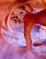
I stopped near Windstone Arch![]() , but a photo tour had beaten me to it. I walked back to Ram Arch, only to
find the other half of the photo tour there. I wandered around the area looking for new formations I hadn't noticed
on previous days. I eventually got a turn at shooting Ram Arch and Windstone Arch before the good light was lost.
, but a photo tour had beaten me to it. I walked back to Ram Arch, only to
find the other half of the photo tour there. I wandered around the area looking for new formations I hadn't noticed
on previous days. I eventually got a turn at shooting Ram Arch and Windstone Arch before the good light was lost.
|
|
| Ram Arch | Windstone Arch |
I had thought about re-shooting Elephant Rock, but then I heard it was the next stop for the photo tour. I decided the Mouse's Tank Road would be a better destination. Once I left the photo tour, I had the rest of the park to myself.
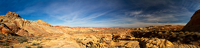
I stopped at Rainbow Vista![]() to shoot panoramas. It's a little like Grandview at Canyonlands. The view is across
this huge area so you loose some of the impact of all the formations. That was the first place
I saw the group shooting a bicycle commercial.
to shoot panoramas. It's a little like Grandview at Canyonlands. The view is across
this huge area so you loose some of the impact of all the formations. That was the first place
I saw the group shooting a bicycle commercial.
I continued up the road toward Parking Lot 2 when I saw a group of cars parked along the road. They must see bighorn sheep. I drove past my destination only to discover it was the group shooting the bicycle commercial again. I continued up the road to Parking Lot 3 and shot a couple panoramas there.
Then I turned around and head south for Parking Lot 2 again. Up ahead was a group of cars and people standing at the edge of the road. Once again, I was faked out into thinking they saw bighorn sheep, and once again it was the people shooting the commercial. Each time, they were friendly and waved. I turned around one last time, passed the camera crew, and drove back toward Kaolin Wash. This is one of the few places you can park along the road between Rainbow Vista and White Domes.
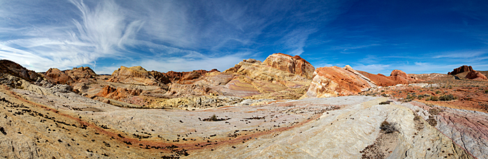
I gathered up all my gear and hiked up the road so I could cut across to the ridge above Crazy Hill![]() .
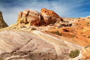
My main goal was to shoot panoramas of the garrish colors of the sandstone, but this had also been a great
place to shoot bighorn. Today, it would be a panorama location. One of the interesting things about this area
was the small igneous bombs that were scattered all over the sandstone ridges above Crazy Hill.
.
My main goal was to shoot panoramas of the garrish colors of the sandstone, but this had also been a great
place to shoot bighorn. Today, it would be a panorama location. One of the interesting things about this area
was the small igneous bombs that were scattered all over the sandstone ridges above Crazy Hill.
On the way back to the Explorer, I stopped to shoot Striped Rock![]() . Then, it was back to camp
to start preparing to return home. We not only had to pack up again, but we also had to do the year-end cleaning.
. Then, it was back to camp
to start preparing to return home. We not only had to pack up again, but we also had to do the year-end cleaning.
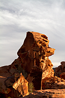
About 4:00, we set out to find Poodle Rock![]() near Arch Rock Campground. We had driven by it five or six times,
but had never seen it in the right light or from the right angle. From the campground exit, it was obvious.
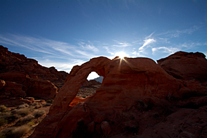
After Poodle Rock, we returned to the Windstone Arch area to shoot sunset. There were a few cirrus clouds
to add interest to the sky, but the sunset was a dud.
near Arch Rock Campground. We had driven by it five or six times,
but had never seen it in the right light or from the right angle. From the campground exit, it was obvious.
After Poodle Rock, we returned to the Windstone Arch area to shoot sunset. There were a few cirrus clouds
to add interest to the sky, but the sunset was a dud.
|
 |
| The Poodle | Sandstone Fins |
We moved to the feature we decided to light and shoot. We brought every flashlight we could find in the motorhome and Explorer. We set everything up, but we lost the ambient light incredibly fast. In the end, we had a practice session with no usuable images. We are going to need a LOT more practice.