

The Wings Hike
We saved the best Bisti hike until last. The Wings are located in the northern part of the Bisti Wilderness. In the past, a separate parking area allowed access to the Wings section with only a one mile hike each way. Now, access to the northern parking area has been closed, and it's a 2.3 mile hike each way from the parking lot in the southern portion. At our age, we feel those two extra miles of hiking.
 Today was a gorgeous day.
Our hike started with puffy "photographer's clouds" and temperatures in the 70's. It was much more comfortable than the 90's on Thursday.
We hiked up the main wash and made the turn to go north up a wide, side wash. We had no problem finding our route using the GPS.
We hiked past a hill that looked like a derby hat and around a striped butte that we named, "The Lighthouse." But we were
very disappointed that we couldn't find the petrified tree stump someone had posted on Google Earth. It appears the person may not
have posted it to the correct coordinates because our GPS said we were right on top of it.
Today was a gorgeous day.
Our hike started with puffy "photographer's clouds" and temperatures in the 70's. It was much more comfortable than the 90's on Thursday.
We hiked up the main wash and made the turn to go north up a wide, side wash. We had no problem finding our route using the GPS.
We hiked past a hill that looked like a derby hat and around a striped butte that we named, "The Lighthouse." But we were
very disappointed that we couldn't find the petrified tree stump someone had posted on Google Earth. It appears the person may not
have posted it to the correct coordinates because our GPS said we were right on top of it.
I knew we had to climb out of the wash and over a divide to reach the Wings Section. We found a relatively
easy way out of the wash and "topped out" on a plateau that separated the north and south wash systems that make up Bisti.
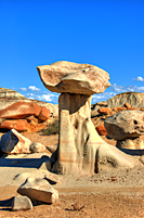
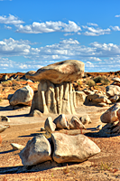
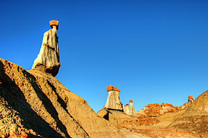
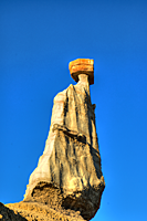
Directly ahead stood The Pedestal.![]() Actually, there were
two quite remarkable hoodoos, both over 6 feet tall.
Either one could have been called The Pedestal. Most of the plateau was very flat with areas dotted with red sandstone rocks interspersed
with remnant layers of weathered sandstone. Huge sandstone boulders surrounded the hoodoos and added foreground interest.
Actually, there were
two quite remarkable hoodoos, both over 6 feet tall.
Either one could have been called The Pedestal. Most of the plateau was very flat with areas dotted with red sandstone rocks interspersed
with remnant layers of weathered sandstone. Huge sandstone boulders surrounded the hoodoos and added foreground interest.
 |
 |
 |
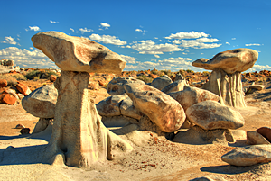
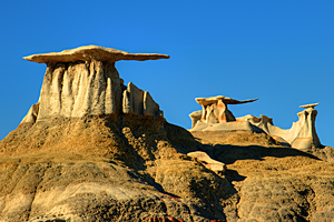
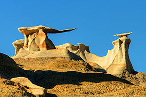
Just beyond The Pedestal, we could see the famous Bisti Wings.![]() What I didn't realize from Google Earth was that
we had to drop into a deep wash to photograph the Wings. We found a photographers trail down a gully and had no problem telling the
most popular locations for shooting the Wings. We also shot other formations around the Wings, but even with the GPS, we never found
the Jetsons Pillar. That will give us another reason to go back to this area.
What I didn't realize from Google Earth was that
we had to drop into a deep wash to photograph the Wings. We found a photographers trail down a gully and had no problem telling the
most popular locations for shooting the Wings. We also shot other formations around the Wings, but even with the GPS, we never found
the Jetsons Pillar. That will give us another reason to go back to this area.
 |
 |
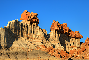
Our final destination was the area I labeled as Hoodoos 6.![]() It was down a side wash just west of the Wings.
We found an entrance to the wash and hiked to the opposite end. There wasn't much to see until we reached the western end of the wash
and hiked up into the side canyons. Carol had seen images of large white sandstone hoodoos with red capstones and wanted to find them.
The side canyons around Hoodoos 6 had huge pillars with red capstones 2 feet tall. One formation was called "The King's Men"
and was very impressive. The formations at Hoodoos 6 may have been our favorites of the day.
It was down a side wash just west of the Wings.
We found an entrance to the wash and hiked to the opposite end. There wasn't much to see until we reached the western end of the wash
and hiked up into the side canyons. Carol had seen images of large white sandstone hoodoos with red capstones and wanted to find them.
The side canyons around Hoodoos 6 had huge pillars with red capstones 2 feet tall. One formation was called "The King's Men"
and was very impressive. The formations at Hoodoos 6 may have been our favorites of the day.
 |
 |
 |
The bad news was that it was 6:00 and the sun was setting fast. We wrapped up our shooting in Hoodoos 6 and followed a different canyon back toward the Wings. Fortunately, the canyon led us right back to the main plateau and only a short distance from The Pedestal. Since we wanted to shoot the Pedestal just before sunset, it turned out perfectly.
When we finished at The Pedestal, it was all about finding the main wash and hiking past the Lighthouse, the Derby, around the barbed-wire fence, and back to the Explorer. We reached the parking lot just before we hit complete darkness. Our trusty GPS did very well.
Tomorrow is a traveling day to Monument Valley. After our six-mile hike today, I think we'll enjoy the day off.