

Adieu
We could put it off no longer. We finally bid adieu to Farmington. After three weeks, it was time to move on.
We skipped Monument Valley and Cedar Breaks completely, and we're only spending three nights in Moab. After Moab, we will be back on-schedule.
Today, we left New Mexico, drove north into Colorado and then west into Utah. We have enjoyed the low gas prices in Farmington because of the low taxes, but it's obvious why their fuel taxes are so low. Road repairs and maintenance seem to be nearly non-existent on their state and local roads (what few local roads are paved or even maintained). I guess they are used to it and accept it, but it's pretty difficult to accept when you're used to good roads and highways. As soon as we crossed into Colorado, the roads were smooth and well-maintained. We noticed the same thing, when we drove to Durango when Carol flew back to San Diego. I think the tire and front-end alignment shops must have a powerful lobby in New Mexico :)
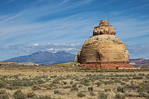
The drive to Moab was scenic and easy. I was surprised at some of the huge farming operations on the plateaus southeast of Monticello. North of Monticello, we dropped into the red rock country we associate with Southern Utah. We stopped near Church Rock for lunch, and then drove the final 35 miles to Moab. We're staying in the Spanish Trails RV Park this year. We have always stayed at the Moab Valley RV Resort in the past, but they were full. They have also gotten very expensive.
Moab Rock Art
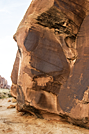
By 3:30, we had everything set up in our campsite, and we were ready to go exploring. Our first stop was only about a mile away on the other side
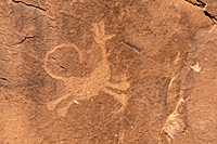
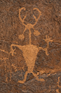
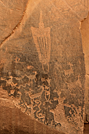
of the highway. "Moab Man"![]() is etched into a large rock
near the golf course. Besides Moab Man, there are bighorn sheep, "the family dog," and a wife watching the kids play.
OK, I'm doing a lot of speculating here, but the panel was interesting.
is etched into a large rock
near the golf course. Besides Moab Man, there are bighorn sheep, "the family dog," and a wife watching the kids play.
OK, I'm doing a lot of speculating here, but the panel was interesting.
 |
 |
 |
| Our Dog Spot? | Moab Man | Mom Watching the Kids Play |
 After Moab Man, we drove
to the Kane Creek Boulevard area of petroglyphs to get acclimated for tomorrow. I had programmed the major petroglyph sites I found
on the Internet into our vehicle GPS, but you never know if the person providing them was being exact, careful, or accurate.
We had no problem finding the Moonflower Canyon
After Moab Man, we drove
to the Kane Creek Boulevard area of petroglyphs to get acclimated for tomorrow. I had programmed the major petroglyph sites I found
on the Internet into our vehicle GPS, but you never know if the person providing them was being exact, careful, or accurate.
We had no problem finding the Moonflower Canyon![]() panel.
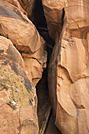
It was small and not terribly interesting. What was more interesting was the "ladder" used to climb to the top of the cliff
overlooking the camping area. Logs have been jammed into a narrow crack in the cliff face to re-create a ladder to the top used
by Native Americans in this area. A guy was coming down this "ladder" when we approached the cliff. It didn't seem like anything I would ever want to try.
panel.
It was small and not terribly interesting. What was more interesting was the "ladder" used to climb to the top of the cliff
overlooking the camping area. Logs have been jammed into a narrow crack in the cliff face to re-create a ladder to the top used
by Native Americans in this area. A guy was coming down this "ladder" when we approached the cliff. It didn't seem like anything I would ever want to try.
We pulled off into a parking area that looked like the trailhead for the Moab Maiden petroglyph trail. It was filled with ATVs and trailers. There was no information about the Moab Maiden, but the area seemed to match what I had seen on Google Earth and on the Internet.
We continued up the road to the next parking area that was even more crowded by bikes, motorcycles, ATVs, and trucks. Once again, there were no signs about the Bighorn Sheep Panel that I thought could be accessed from this area, but everything looked right. I just couldn't see the trails that climbed the ridge to the the cliff base where you begin seeing the petroglyphs.
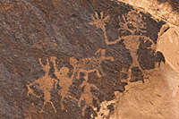
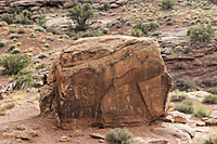
We continued up the road until I saw the "Birthing Rock."![]() I had seen
lots of pictures of it, and it was right below the road. We parked in the pullout and walked back to join the group looking
at the petroglyphs. The large boulder had petroglyphs on all sides, but the side facing the road had the birthing scene and the main petroglyphs.
I had seen
lots of pictures of it, and it was right below the road. We parked in the pullout and walked back to join the group looking
at the petroglyphs. The large boulder had petroglyphs on all sides, but the side facing the road had the birthing scene and the main petroglyphs.
 |
 |
As I was walking around the Birthing Rock, I looked at the formations to the west and recognized the trail and features near the Owl Panel. We were never able to see the Owl Panel, even with binoculars, but we could see the trail on the ridge across the wash and the general features on the cliff near the panel. I definitely have some things to look up in Google Earth tonight.
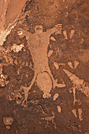
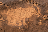
Our final planned stop for the day was trying to find the mastodon petroglyph.![]() The GPS
told us where the turnoff was, and we drove up a very rough road to a parking area. From there, we hiked a 4x4 road along huge
fossilized sand dunes until we spotted the mastodon. It wasn't huge or anything, and it reminded me of the logo for Mammoth Mountain.
There were a few other human figures in the area, but the mastodon was the star.
The GPS
told us where the turnoff was, and we drove up a very rough road to a parking area. From there, we hiked a 4x4 road along huge
fossilized sand dunes until we spotted the mastodon. It wasn't huge or anything, and it reminded me of the logo for Mammoth Mountain.
There were a few other human figures in the area, but the mastodon was the star.
 |
 |
We found two other smaller petroglyph areas on the way back to town, but they weren't anything compared to the other panels.