

Colorado River Day
We never strayed more than a mile from the Colorado River today. We slept in and then drove down to the road that follows the north edge of the Colorado River. The road meanders along the river with red cliffs separating it from the fossilized sand dunes above it.
As soon as we turned onto the road to drive up the river, we passed the Department of Energy superfund clean-up site. The Moab area was a critical source for uranium in the mid 50's as the United States was developing atomic energy. The flats just north of town and right next to the Colorado River became a dumping ground for the uranium waste from the Atlas Corporation mill site. At some point, someone started asking about the leaching of these substances into the Colorado River and into the drinking water of millions of people. Eventually, they decided maybe this wasn't such a good thing, and they started planning for the clean-up. We've watched it progress through the years from the original dump site, to the construction of a special spur railroad line, to hauling the most dangerous wastes to a special disposal site by railroad, and to the the current work of burying less dangerous waste into a huge hole they have excavated. I'm assuming they have lined this new disposal area to ensure no contaminants can leach into other areas. If they continue to get funding, they hope to finish the clean-up by 2025. It is a HUGE project funded by the taxpayers because Atlas Corporation declared bankruptcy and walked away.
Shortly after we passed the cleanup site, the Colorado River changed from a river flowing through a flood plain to flowing through a red sandstone canyon. For the first few miles, there were rock climbers practicing on the cliffs next to the road any place there was room to park. With snow and cold in the Rockies, I guess this would be a great place to practice.
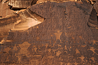
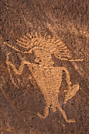
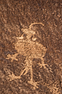
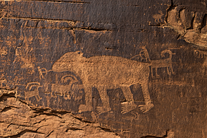
After about 5 miles, we reached the first rock art panel. It was interesting that the sign along the road pointed to "Indian Writings." I hadn't thought of them as "writings," but I guess they can tell a story. There were several large panels of petroglyphs from the Archaic and Fremont cultures. Fortunately, they were high enough up the cliff that there has been very little vandalism to the main panels. There were lots of bighorn sheep and people with very triangular-shaped bodies and cool horns. There was also a guy in a very fashionable headdress. Earrings also seemed to be "in" during this time.
 |
 |
 |
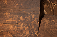 |
The second panel was about 1/2 mile farther up the road and had a bear as the central figure. There are at least two tiny men shooting the bear with bow and arrows. There area also a few bighorn sheep, but the bear is clearly the star of this panel, and the people's perception of their relative power is obvious.
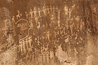
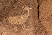
We found a third panel that was much smaller than the first two, but it was very interesting in its "story telling." There appears to be at least one family portrait with a group of nine holding hands. There is another group of 4 with a "line" etched to connect them to a bighorn sheep. Between the sheep and the people are a group of marks that may be a scorecard to note the number of bighorn sheep they had killed. The panel also included a bird. Around the corner and up a side canyon, we found another panel that included a huge elk standing beside a tall tree with three bighorn sheep. Unfortunately, this panel was in deep shade and the etching was very light. It was very difficult to get a photograph that clearly shows the elk. We'll try again on next year's trip.
 |
 |
I had researched and marked all the petroglyph locations I found in our vehicle GPS. A couple more miles up the road, the GPS told us of the next petroglyph location and a pullout seemed to confirm it. We found a trail through the bushes and small trail toward a sandstone cliff beside the wash. We figured the petroglyphs would be there. Nope. We found lots of footprints in the wash, so we continued hiking through the brush, over the downed tree limbs and finally over a small ridge to bypass and dry waterfall. We kept hiking about 3/4 miles until we ran out of canyon. We turned a corner and there was an alcove with a small pool of water and towering sandstone cliffs hundreds of feet tall. It was gorgeous and amazing! The bottom of the canyon was all damp sand with a ridge to our left that was probably 50 feet high and in front of the canyon wall. The canyon wall had a cave in the sandstone and then towered high above it. After looking all over, we have speculated that the petroglyphs must be somewhere above that ridge on the canyon wall. There must be a way to get up on the ridge, but we couldn't find it.
Eventually, we returned to the Explorer and drove along the Colorado as far as Corona Arch. We ate lunch in a nearby campground parking lot. The BLM has done a great job of developing the area along the Colorado River. The first time I camped in this area, the "campgrounds" were simply open areas along the river bottom, and they were a mess. People camped wherever they wanted and left their trash behind. Now the campgrounds are developed without losing their "wild" feel. They're still for the "hardy" camper, but they are clean, have restrooms, and are easier to access.
 By the time we finished lunch,
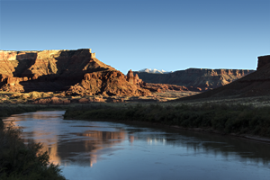
it was about 4:30. As we returned upriver, the light was warming and the Colorado River mirrored the rocks where we found the Moab Mastodon yesterday.
After we stopped to shoot the reflections in the river, we continued along the Colorado River east of Moab.
I have wanted to shoot the classic Fisher Towers over the Colorado River at sunset shot for many years, but the timing was always wrong.
This time, the conditions looked very promising.
By the time we finished lunch,
it was about 4:30. As we returned upriver, the light was warming and the Colorado River mirrored the rocks where we found the Moab Mastodon yesterday.
After we stopped to shoot the reflections in the river, we continued along the Colorado River east of Moab.
I have wanted to shoot the classic Fisher Towers over the Colorado River at sunset shot for many years, but the timing was always wrong.
This time, the conditions looked very promising.
I had forgotten how far up the river Fisher Towers was. I had hiked one of the major trails in the area, but that was years ago. The GPS telling us it was 25 miles to our shooting location was a bit of a shock. The drive up the river wasn't fast, but it's very scenic. The highway follows the river canyon the entire way and sometimes feels like it's right over the river. There are very few, if any, rapids in this area. We even saw a group on paddle boards in the middle of the Colorado. We see them all the time along the Southern California coast, but they seemed all wrong in Utah.
We had no problem finding the spot for the classic shot of Fisher Towers.![]() There was a large pull-off, complete with a raised,
paved area to make it easier to shoot over the tamarisk trees along the river. It was only about 5:15, so we had a lot of time before sunset.
We set up and tried lots of locations as the light changed. As sunset neared, the breeze died down, and we had nearly perfect reflections
in the river. There was a little snow on the La Sal Mountains, but the sky was absolutely clear. We desperately need some clouds to complete the scene.
The rocks of the canyon walls glowed on queue and Fisher Towers caught just enough light from the setting sun that we got some very nice images.
They won't be spectacular, but they should convey the tranquility of the scene.
There was a large pull-off, complete with a raised,
paved area to make it easier to shoot over the tamarisk trees along the river. It was only about 5:15, so we had a lot of time before sunset.
We set up and tried lots of locations as the light changed. As sunset neared, the breeze died down, and we had nearly perfect reflections
in the river. There was a little snow on the La Sal Mountains, but the sky was absolutely clear. We desperately need some clouds to complete the scene.
The rocks of the canyon walls glowed on queue and Fisher Towers caught just enough light from the setting sun that we got some very nice images.
They won't be spectacular, but they should convey the tranquility of the scene.
 |
 |