

The Dinosaur Quarry
 Today
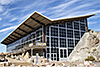
was a great day! Our first stop was the quarry at Dinosaur National Monument. The quarry is actually a two-story building built over a rock wall
full of dinosaur bones. The building is nearly all windows, and the lighting conditions change by the minute as the sun is shaded or peeks
through the clouds. It might be easier to shoot on a bright cloudy day. Today, the lighting changed constantly and varied from warm and soft to harsh and gray.
Today
was a great day! Our first stop was the quarry at Dinosaur National Monument. The quarry is actually a two-story building built over a rock wall
full of dinosaur bones. The building is nearly all windows, and the lighting conditions change by the minute as the sun is shaded or peeks
through the clouds. It might be easier to shoot on a bright cloudy day. Today, the lighting changed constantly and varied from warm and soft to harsh and gray.
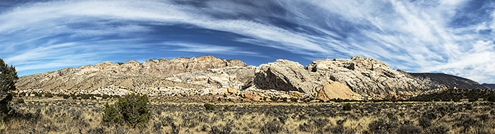
At one time, this area was a shallow lake with streams feeding into it. As dinosaurs died, their skeletons were washed into the lake basin and were preserved in the mud at the bottom of the lake. At some point, the layers in area were drastically folded so they are now standing vertically on end instead of horizontally. The rock wall in the Dinosaur Quarry exhibit is one layer of mud that used to be at the bottom of the lake. The view from the second "deck" provides a unique view straight across at some of the largest bones, while the bottom floor allows you to get up close and even touch a dinosaur bone. The remains of over 500 dinosaurs and other animals have been taken out of the quarry and are in museums all over the country. The bones we saw today were the "leftovers" after the remains of these dinosaurs had been removed. The quarry was much more impressive than I thought it would be.
 |
 |
 |
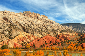
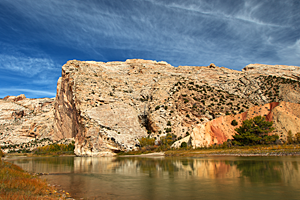
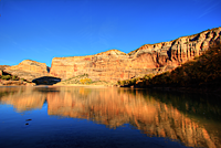
Split Mountain
Our second stop was the Split Mountain Marina.![]() The road dropped down from a plateau to
be level with the Green River. The Green River
has split a mountain to continue its journey south. In this section, the Green River is deep and flows serenely through the monument. In places,
we could even get reflections of the mountain in the river. We talked to two rangers who had just finished their last patrol of the river
for the season. They were unloading their raft and packing all their gear into a truck. While we were standing there, I saw the familiar
white butts of bighorn sheep across the river. They were probably 1/4 mile away, but I was pretty sure that's what I was seeing. The rangers
confirmed that a herd of bighorn were feeding right at the edge of the river when they floated by. We grabbed our long lenses out of the Explorer
and got as close as we could without getting wet. Although they were a long way away, it was still very cool to see them.
The road dropped down from a plateau to
be level with the Green River. The Green River
has split a mountain to continue its journey south. In this section, the Green River is deep and flows serenely through the monument. In places,
we could even get reflections of the mountain in the river. We talked to two rangers who had just finished their last patrol of the river
for the season. They were unloading their raft and packing all their gear into a truck. While we were standing there, I saw the familiar
white butts of bighorn sheep across the river. They were probably 1/4 mile away, but I was pretty sure that's what I was seeing. The rangers
confirmed that a herd of bighorn were feeding right at the edge of the river when they floated by. We grabbed our long lenses out of the Explorer
and got as close as we could without getting wet. Although they were a long way away, it was still very cool to see them.
 |
 |
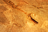
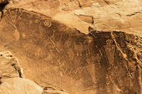
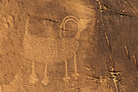
Cub Creek
The Cub Creek Panels![]() provided the petroglyphs for the day.
We drove along a canyon floor and found two good panels of petroglyphs. The first panel was right next to the road. The panels included a very interesting guy
with huge earrings, several bighorn sheep, and a guy that seems to hold a bighorn by the leg. Access to some of the more impressive petroglyphs was blocked
due to a rock slide. They appeared to be larger and include more people than the ones closer to the road.
provided the petroglyphs for the day.
We drove along a canyon floor and found two good panels of petroglyphs. The first panel was right next to the road. The panels included a very interesting guy
with huge earrings, several bighorn sheep, and a guy that seems to hold a bighorn by the leg. Access to some of the more impressive petroglyphs was blocked
due to a rock slide. They appeared to be larger and include more people than the ones closer to the road.
 |
 |
 |
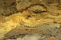
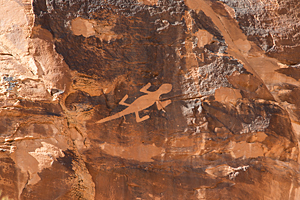
The second panel along Cub Creek was definitely done by a lover of lizards. This panel required a short hike up to a cliff where the petroglyphs were chipped into the sandstone. But even from the Explorer, we could see one lizard petroglyph that must have been 3 - 4 feet long. It was huge! There were a few primitive human petroglyphs, but the huge lizard and the four or five smaller lizards were definitely the stars of the panel.
 |
 |
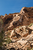
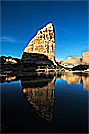
Echo Park
From Cub Creek, we had to retrace our route and leave the monument, drive east on Highway 40 for 20 miles, and then re-enter
the monument near Dinosaur, Utah. From Dinosaur, it was another 20 miles driving on a high plateau until we reached the "road"
to Echo Park.![]() We alternated between driving across flat plateaus and dropping into steep walled canyons for 18 miles. The top part
of the road was very rough where the road was rounded sandstone rocks packed together to make a road, but the rocks were large
enough that we felt every rock as we crossed over it. After about 1/2 mile, the road steepened but got much smoother. Just before we reached
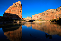
the bottom and Echo Park, a huge bull elk crossed the road in front of us and charged over the ridge. As we exited the final narrow canyon,
the scene opened up to a giant meadow in the flood plain of the Green River. A large herd of elk fed along one side of the meadow as it stretched
to the red rock walls on the opposite end of the canyon. We parked off the road and walked through a gap in the trees toward the river. Suddenly,
Steamboat Rock stood before us with the river curving between us and the rock. To our right, the river flowed through a huge meander
and reflected a striking red canyon wall. The area was gorgeous!
We alternated between driving across flat plateaus and dropping into steep walled canyons for 18 miles. The top part
of the road was very rough where the road was rounded sandstone rocks packed together to make a road, but the rocks were large
enough that we felt every rock as we crossed over it. After about 1/2 mile, the road steepened but got much smoother. Just before we reached
the bottom and Echo Park, a huge bull elk crossed the road in front of us and charged over the ridge. As we exited the final narrow canyon,
the scene opened up to a giant meadow in the flood plain of the Green River. A large herd of elk fed along one side of the meadow as it stretched
to the red rock walls on the opposite end of the canyon. We parked off the road and walked through a gap in the trees toward the river. Suddenly,
Steamboat Rock stood before us with the river curving between us and the rock. To our right, the river flowed through a huge meander
and reflected a striking red canyon wall. The area was gorgeous!
Echo Park is in a deep canyon so we had to hurry to get our images before the sun set behind the ridge. The huge size of Steamboat Rock and the proximity to the river (and us) required a trip back to the Explorer to get our 10 - 22 mm zoom lenses. Even with these super-wide angle lenses, we could barely get Steamboat Rock and the river in the same shot. Within 15 minutes, the shadows started inching up Steamboat Rock as the sun dropped lower in the sky. By that time, the river was so still that it looked more like a lake than a river. It was like a mirror. After 30 minutes, the sun was gone. We really needed to be there at least an hour earlier.
When we walked back to the Explorer, a huge herd of deer were feeding in the meadow beside the road. I can understand why people camp in Echo Park. It's a bit of paradise hidden away deep in the canyons of the Green River.
I doubt there is any way that the images will begin to show the beauty of Echo Park. It was a great way to end our time at Vernal.
 |
 |
 |