

Third Time Is the Charm
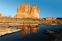
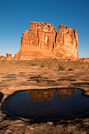
I wanted one more chance to get sunrise light on the potholes near the Courthouse Towers, so I got up for sunrise again. Carol had already gotten the shots she wanted, so she slept in.
As I drove toward Moab, the supermoon seemed to parallel me along the ridges west of town. It appeared absolutely huge. It was still pitch black, so there was no way to photograph it with any foreground. Besides, I had a mission to finally get the warm light on the formations reflected in the wash potholes.
There were no clouds over the La Sal Mountains. That meant no pre-dawn light show, but it also meant the sun would shine down on the wash as soon as it cleared the mountains. There would be no veil of clouds to soften the light. It was looking promising. As sunrise neared, I hiked out to the pothole I selected to stake out my spot. It was a good thing, too, because I soon had company in the wash. When the sun rose, there was only blue sky as a background, but the sunrise light painted each formation with a warm glow. I was getting the light I wanted.
I finished the two potholes that were my top priorities. Then I walked over to shoot the spot Carol found yesterday. It was a good reflection shot, and it had the added interest of a plant in the foreground. From there I found the "jigsaw puzzle" shot. The reflections of the wash and formations were scattered across the sandstone wash in the collection of puddles. And then the warm light was gone...
 |
 |
 |
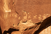
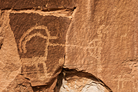
Bighorn Sheep Panel
I returned to camp and enjoyed a nice warm shower, before we set out on our pursuit of more petroglyphs. We saw the area of the
Bighorn Sheep Panel![]() when we were in Moab two weeks ago.
Today, we would climb up to the cliffs and try to find them. Our first obstacle
was the HBO crews. They had reserved most of the parking lot at the trailhead. They are filming an HBO series in the Moab area. This is
the second time we've run into them. Luckily, a nice Moab police woman let us do some creative parking, so we could do our hike.
While we were talking to the police woman, we heard a CRACK and looked toward the cliffs to our left to see a paraglider coming down.
As soon as he reached the ground, we heard another crack and saw a second paraglider. The sound was so sharp and loud, at first I thought
it was a stunt for the HBO series where they were fired out of some kind of cannon to propel them away from the cliff face. But then
I saw a third paraglider standing on the edge of a formation atop the cliff. I realized we were hearing the crack of the chute opening
as they jumped off the cliff. After the third guy jumped, the police woman said they have a competition around Thanksgiving each year
where they jump on this cliff and try to get closest to a target in the canyon bottom below us. The paragliders hike through the canyon
below the petroglyphs we're looking for, up to the ridge above the canyon, behind the formations atop the cliff face, and then climb
to a beehive formation where they jump off. All that hiking for a 30 second "flight."
when we were in Moab two weeks ago.
Today, we would climb up to the cliffs and try to find them. Our first obstacle
was the HBO crews. They had reserved most of the parking lot at the trailhead. They are filming an HBO series in the Moab area. This is
the second time we've run into them. Luckily, a nice Moab police woman let us do some creative parking, so we could do our hike.
While we were talking to the police woman, we heard a CRACK and looked toward the cliffs to our left to see a paraglider coming down.
As soon as he reached the ground, we heard another crack and saw a second paraglider. The sound was so sharp and loud, at first I thought
it was a stunt for the HBO series where they were fired out of some kind of cannon to propel them away from the cliff face. But then
I saw a third paraglider standing on the edge of a formation atop the cliff. I realized we were hearing the crack of the chute opening
as they jumped off the cliff. After the third guy jumped, the police woman said they have a competition around Thanksgiving each year
where they jump on this cliff and try to get closest to a target in the canyon bottom below us. The paragliders hike through the canyon
below the petroglyphs we're looking for, up to the ridge above the canyon, behind the formations atop the cliff face, and then climb
to a beehive formation where they jump off. All that hiking for a 30 second "flight."
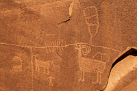
We hiked up the steep and rocky use-trail to the base of the cliff. We definitely had to work to get to the petroglyphs. As soon as we reached the base of the cliff, we started seeing petroglyphs. Fittingly, many of them included bighorn sheep. Although many of them were difficult to photograph because of the light sandstone they were chipped into, they were remarkable. They were some of the best we've seen. We found new small panels all along the cliff base as we hiked up the canyon. They were worth every bit of effort we'd expended. We also saw some of the worst vandalism we've seen. We saw at least two examples of someone trying to use some kind of sharp blade to cut out and steal petroglyphs.
 |
 |
 |
We reached a point where huge chunks of the sandstone cliff had broken away and crashed down toward the canyon bottom. We climbed over, around, and through the obstacle course of boulders. When we reached the other side of the rock fall, we were in a smaller canyon clothed in oak trees. The GPS told us we were looking right at the petroglyphs, just across a deep wash. But we couldn't see the petroglyphs. We walked all over, retraced our steps, re-checked the compass, and finally had to admit defeat. We could not find the petroglyphs. We followed a climbers trail back down to the main canyon bottom and returned to the Explorer. This trail was even steeper than the way up to the cliff and definitely wasn't maintained. We eventually figured out from the trail description that we didn't go far enough up the canyon to see the petroglyphs. We had to climb out of the canyon through a tiny gap in the wall to reach the next ledge above us. The GPS told us exactly where to look; it just had no way to tell us they weren't visible from our vantage point because they were a ledge above us. I've been carrying my iPad with all the trail descriptions with me when we hike, but I decided to skip carrying a pack for such a steep and short hike. Bad choice. Even without the final Bighorn Sheep Panel, we saw some great rock art.
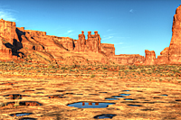
Sunset Potholes
 We ate
our sack lunches and returned to La Sal Mountain Overlook
We ate
our sack lunches and returned to La Sal Mountain Overlook![]() in Arches where we shot moonrise last night. We wanted to photograph a formation that
lit well just before sunset last night. We were too late to find a good way to shoot it last night, so we wanted to give ourselves plenty
of time to get everything worked out today. We hiked down to the slickrock area and wandered all over looking for the best vantage point
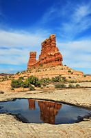
to shoot the formation. I finally found a pothole that reflected the formation almost right at the base of the formation. We had to do all kinds
of contortions to get the shot and not have our shadows in the images, but we eventually got some good images. Carol wasn't satisfied with the shot
and decided to look for more options to the north. I decided to go back to some of the areas I had seen last night for shots of the La Sals.
Carol eventually found her perfect shot. In fact, she found two perfect shots. I enjoyed wandering around on the slick rock, but I didn't
really get anything special. The rolling textured sandstone of the slick rock areas has always fascinated me. Pocked with potholes, sometimes
filled with water and sometimes filled with plants, the slickrock stretches for a couple of miles above the Courthouse Wash. And just on the
other side of the wash are the petrified dunes that stretch toward the La Sal Mountains. It's quite an incredible area.
in Arches where we shot moonrise last night. We wanted to photograph a formation that
lit well just before sunset last night. We were too late to find a good way to shoot it last night, so we wanted to give ourselves plenty
of time to get everything worked out today. We hiked down to the slickrock area and wandered all over looking for the best vantage point
to shoot the formation. I finally found a pothole that reflected the formation almost right at the base of the formation. We had to do all kinds
of contortions to get the shot and not have our shadows in the images, but we eventually got some good images. Carol wasn't satisfied with the shot
and decided to look for more options to the north. I decided to go back to some of the areas I had seen last night for shots of the La Sals.
Carol eventually found her perfect shot. In fact, she found two perfect shots. I enjoyed wandering around on the slick rock, but I didn't
really get anything special. The rolling textured sandstone of the slick rock areas has always fascinated me. Pocked with potholes, sometimes
filled with water and sometimes filled with plants, the slickrock stretches for a couple of miles above the Courthouse Wash. And just on the
other side of the wash are the petrified dunes that stretch toward the La Sal Mountains. It's quite an incredible area.
Since we had nothing else to do or place to go, we decided to sit in the Explorer in the parking lot and watch the moonrise again tonight. We probably waited about 40 minutes. We had no intention of photographing moonrise because it would be dark by the time it came up. But when the moon started to peek over the horizon, we both jumped out of the car and grabbed our tripods and cameras. There is something about a huge moon on the horizon that mesmerizes me. I only had my 200 mm lens, so I knew the moon would be very small in the frame. Nevertheless, I still needed to shoot the moonrise. Three minutes after it cleared the horizon, the moon was shrouded by clouds and the show was over.