

Today was a very full day that started with the drive to hike up to view the Angel Glacier on Mt. Edith Cavell. Although the day was overcast and a bit gray, we didn't want to miss Mt. Edith Cavell. It is one of the most prominent peaks around Jasper and was covered with snow even this late in the season. The mountain was named for a nurse in World War I that refused to leave when the Germans overran her home town. She continued to care for both Germans and Allies. She was eventually executed by the Germans when they discovered she was helping Allied soldiers to escape. She had helped at least 200 soldiers escape to freedom.
 The road to Mt. Edith Cavell was a narrow, rough road that seemed to go on forever.
The twenty miles took nearly an hour. From the parking lot, it was
only a short hike to the ridge overlooking the glacial lake and
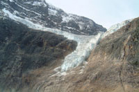
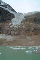
Angel Glacier. Angel Glacier hangs off the side of Mt. Edith Cavell
like an angel soaring up toward the heavens.
The road to Mt. Edith Cavell was a narrow, rough road that seemed to go on forever.
The twenty miles took nearly an hour. From the parking lot, it was
only a short hike to the ridge overlooking the glacial lake and
Angel Glacier. Angel Glacier hangs off the side of Mt. Edith Cavell
like an angel soaring up toward the heavens.
Continuing down the trail, we reached the glacial lake that is fed by Angel Glacier. The water in the lake is barely above freezing and chunks of ice still float in the lake. The turquoise waters were dull from the gray skies and could only hint about the beauty of the area if the sun was shining in a blue sky. A small waterfall connected the toe of the glacier with the area around the glacial lake. While we were there a small chunk of ice calved from the glacier beside the lake and made an echoing boom. For such a small chunk, it was awfully loud. We hiked the remainder of the loop and returned to the car.
 On the way up the mountain, we had passed the trail to Lake Cavell. We had seen photos of the reflections of Mt. Cavell in the lake and had hoped
to see if we could find the lake and where to get this photograph. We stopped by the trailhead and I walked down to see if
I can find a sign providing the distance to the lake. I never found a sign, but I found the lake after only a five minute walk.
I walked back and got Carol and we had our picnic lunch on a bench on the bridge over the outlet stream. We took a few photos,
but the lighting was wrong, the sky was gray, and there were no reflections.
On the way up the mountain, we had passed the trail to Lake Cavell. We had seen photos of the reflections of Mt. Cavell in the lake and had hoped
to see if we could find the lake and where to get this photograph. We stopped by the trailhead and I walked down to see if
I can find a sign providing the distance to the lake. I never found a sign, but I found the lake after only a five minute walk.
I walked back and got Carol and we had our picnic lunch on a bench on the bridge over the outlet stream. We took a few photos,
but the lighting was wrong, the sky was gray, and there were no reflections.
From Lake Cavell, it was back down the mountain to the "best kept secret in Jasper National Park." Beauty Creek isn't listed on any brochures from the parks as a good destination, but our photo guide had recommended it and provided the directions on finding it. It was a good thing we had the directions. The trailhead was an unsigned parking area for about four cars out in the middle of nowhere. It was, indeed, a well-kept secret.
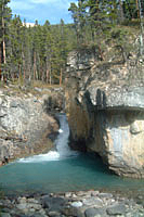
The highlight of the hike was to be Stanley Falls, a round trip of less than four miles. It was mid afternoon, so we figured we had plenty of time and didn't need to take all of our extra emergency gear, etc. We took only one tripod, to cut the weight somewhat and started hiking across this level flood plain. After a half mile, we came to Beauty Creek, which sliced through the mountain ridge. After that, it was one waterfall after another pouring into turquoise pools. It seemed like each turn in the trail found another cascade or waterfall.
We hiked in about two miles along the trail and came to one final cascade that we figured had to be Stanley Falls because the trail guide and maps said that it was only about two miles from the trailhead. Fortunately, we ran into Byron and Heidi who had been there many times before. Byron assured us that this small cascade was not Stanley Falls, but that it was only about another mile. After hiking another mile, we ran into them again along the trail as they took a rest break. Once again, Byron told us it was only about another mile. This wasn't so re-assuring because the trail had deteriorated a bit and in several places was just a path on very steep clay slopes that dropped forty feet into the stream below. In several places, it was only about six inches wide and slick. Because it was supposed to be a short, easy hike, we were in tennis shoes. The tread on my shoes was getting smooth, so I had a few tense moments cutting across some of these clay slopes. In fact, in a couple of places, I left the trail and climbed up and over a ridge rather than trust my shoes on the clay slopes.
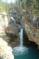
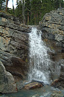
We were watching the sky as it began to cloud up, and the sun kept getting nearer to setting on the mountains to the west. Just as we were about ready to give up, we finally caught up with Byron and Heidi at Stanley Falls. It was almost unbelievable. We scrambled down some rocks to stand right beside Beauty Creek. From there we were at the apex of three waterfalls. Stanley Falls flowed beneath a rock ridge and then dropped into the valley below. Byron told us we could hike up and actually stand on the rock and have the waterfall flow beneath us. We were too tired, and it was too late to check that out.
Opposite Stanley Falls, was a cascade and waterfall that flowed from the top of the ridge and then dropped right in front of us in a final waterfall. On the third apex of the triangle was a small cascade that feathered into the stream. It was amazing, but it was also getting dark and all of our blue sky was long gone.
Our photos can't even begin to show the beauty of this area.
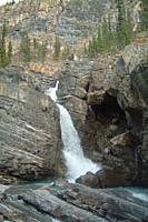
Beauty Creek Images
 |
 |
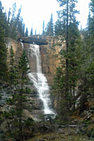 |
| First Waterfall | Beauty Creek Waterfall | Stanley Falls |
 |
 |
| Unnamed Falls | Unnamed Cascade |
Hiking in the dark along a heavily forested stream in grizzly country didn't seem like a good idea, so we had very little time to enjoy Stanley Falls. We didn't have bear bells, so we resorted to talking loud and singing any song we knew some of the words for. We finally hiked out of the mouth of the canyon just as it was getting dark. We had made it safely, but we had also missed one of the best sunsets of the trip. We could see the sky light up and turn pink through the forest as we hiked out, but we had no chance to take any photos.
Final mileage at Beauty Creek: Our 4 mile hike was actually an 8.5 mile hike. We had the feeling that Stanley Falls was also a secret from the writer of the photo guide. Perhaps, he also thought the last large cascade was Stanley Falls. Fortunately, I had turned on the tracking functionality on my GPS when we left the car, so we had an accurate record of our hike. It was a very long day, but it's a hike we will definitely repeat by hiking directly to Stanley Falls with the goal of reaching it about noon for best lighting. Then we will photograph the other cascades and waterfalls during the afternoon on our way out when the lighting shifts to the west.