Today was one of our major driving days as we left Massachusetts and headed for the leaf country of Vermont. By the time we were all packed up and heading west, we got a very nice surprise. The clouds that had taken over southern Vermont began to break up, and we even got some sun. For the past two weeks, every weather forecast for the area has said at least a solid week of rain starting the day we arrived in Boston. We may still get lots of rain, but at least it wasn't today.
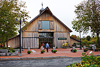 Shortly after we arrived in Vermont, we stopped at a rest stop on Interstate 91 that was definitely the nicest one I've ever
seen. It was like a small park with a very fancy
visitor information building. We picked up lots
of brochures for ideas of things to do in case
we couldn't do the photographic trips we planned
because of rain.
After we exited the Interstate, we drove north through the hilly
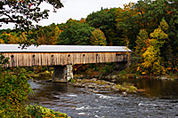
countryside of Vermont. Our first stop was the West Dummerston Covered Bridge.![]() It turned out to be
a very busy bridge as we dodged cars trying to
get our photos.
It turned out to be
a very busy bridge as we dodged cars trying to
get our photos.
Then it was on to a couple classic
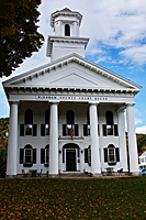
New England little towns. We photographed the main square in
Newfane![]() with the 3 churches, the bed and breakfast, and the courthouse.
I even found the house I wanted to buy, but it seemed like a
very long commute.
with the 3 churches, the bed and breakfast, and the courthouse.
I even found the house I wanted to buy, but it seemed like a
very long commute.
|
|
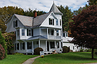 |
| Dummerston Bridge | Court House in Newfane | Cool House |
Our next stop was Townshend![]() with another classic white church and a flea market in the town square.
We continued north toward Jamaica State Park. The fall color
hadn't reached the valley bottoms yet, so we skipped shooting
along the river there.
with another classic white church and a flea market in the town square.
We continued north toward Jamaica State Park. The fall color
hadn't reached the valley bottoms yet, so we skipped shooting
along the river there.
And then we missed a turn...Again. Our plan was to cross the Green Mountains on the Kelly Stand Road, which promised to be one of our most scenic drives. In fact, the plan was to scout it today and then shoot it in earnest tomorrow. Instead, we continued south and crossed the Green Mountains on Highway 9. That lead us right into Bennington, which is where our motel was. Unfortunately, it missed the scenery that was the day's priority. It was only 2:00 when we reached Bennington, so we decided to make a quick run north and see if we could still shoot sunset on the Kelly Stand Road.
We drove north on Highway 7 and promptly missed the turn to access the Kelly Stand Road. That meant we had to drive all the way to Manchester Center before we could turn around. We just aren't getting along with the signage in Vermont at all.
 By the time we reached the Kelly Stand Road, the sun was starting to sink in the sky and the river that we wanted
to photograph was shrouded in shadows. We could see the potential for photos, but it wouldn't be today.
We continued up the road to look for one of the three ponds to shoot sunset. The first sign we saw was for Branch Pond,
so we made the turn and started up the road. After 3 miles the road came to a dead end with a sign that said Branch Pond
was 0.3 miles back the way we had just come. We turned around, checked our odometer and returned back down the road trying
to find the pond. I'm sure it's out there, but we never found it. Instead, we decided to continue up the main road to Grout Pond,
By the time we reached the Kelly Stand Road, the sun was starting to sink in the sky and the river that we wanted
to photograph was shrouded in shadows. We could see the potential for photos, but it wouldn't be today.
We continued up the road to look for one of the three ponds to shoot sunset. The first sign we saw was for Branch Pond,
so we made the turn and started up the road. After 3 miles the road came to a dead end with a sign that said Branch Pond
was 0.3 miles back the way we had just come. We turned around, checked our odometer and returned back down the road trying
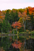
to find the pond. I'm sure it's out there, but we never found it. Instead, we decided to continue up the main road to Grout Pond,![]() which was supposed to be the main pond along this road. We arrived just before the sun dropped behind the hill,
so we got a few minutes of warm light on the trees. We could see the area had potential,
but most of the trees were already past prime color.
which was supposed to be the main pond along this road. We arrived just before the sun dropped behind the hill,
so we got a few minutes of warm light on the trees. We could see the area had potential,
but most of the trees were already past prime color.
Then it was back down the mountain and south to Bennington to find our motel in the dark. Fortunately, it only took us two tries to find it.

