

Happy Anniversary to us! It doesn't seem possible that we've been together for 16 years until we count all the trips we've done and all the special moments we've shared. Two of our kids are now married, and the third has just gotten engaged. We've been to almost every major national park in the West and several in Canada. But there isn't a more appropriate place for us to spend our anniversary. Camping at Yosemite is where our friendship started the transition to a life-long commitment.
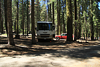 We had an easy drive into Yosemite and arrived at Crane Flat about 2:00. In sharp contrast to our May trip, our campsite
is large with plenty of flat area to level the motorhome. We even have enough clearing in the trees to get a couple of hours
of solar charging for our inverter system. The campground is at 6,000 feet, so the temperatures are very comfortable:
low 70's during the day and evenings in the mid 50's. Because we only had about 50% of the normal snow in the Sierras
this year, the campground opened weeks earlier than usual, and the meadow that surrounds the campground on two sides is
already blooming with white bistort, pink shooting stars, and dark purple death camas.
We had an easy drive into Yosemite and arrived at Crane Flat about 2:00. In sharp contrast to our May trip, our campsite
is large with plenty of flat area to level the motorhome. We even have enough clearing in the trees to get a couple of hours
of solar charging for our inverter system. The campground is at 6,000 feet, so the temperatures are very comfortable:
low 70's during the day and evenings in the mid 50's. Because we only had about 50% of the normal snow in the Sierras
this year, the campground opened weeks earlier than usual, and the meadow that surrounds the campground on two sides is
already blooming with white bistort, pink shooting stars, and dark purple death camas.
After we got everything set up in camp, we drove to the Valley to see what we could photograph. By the time we got to Tunnel View, it was obvious the shadows were beginning to cover the Valley. No problem. Our next stop would be Washburn Point on the Glacier Point Road.
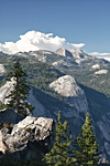
Washburn Point![]() provides an amazing side view of Half Dome, as well as views down to Vernal and Nevada Falls.
And for those contemplating the Panorama Trail, you can look down to Illilouette Falls and the trail as it
crosses the plateau to meet up with the Mist Trail near Vernal Falls. I'd love to do the Panorama Trail,
but it's 8.3 miles nearly all downhill from Glacier Point to Happy Isles. 8.3 miles might be a bit too much downhill in one day.
provides an amazing side view of Half Dome, as well as views down to Vernal and Nevada Falls.
And for those contemplating the Panorama Trail, you can look down to Illilouette Falls and the trail as it
crosses the plateau to meet up with the Mist Trail near Vernal Falls. I'd love to do the Panorama Trail,
but it's 8.3 miles nearly all downhill from Glacier Point to Happy Isles. 8.3 miles might be a bit too much downhill in one day.
The late-afternoon light and clouds over the Sierra crest provided plenty of opportunities for good images. We shot 180-degree panoramas from Washington Column on the north to the Clark Range on the south. My favorite shot was from a new-found angle that included a pine tree helping to frame a view of Basket Dome and Mt. Hoffmann in the distance.
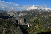
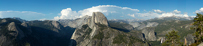
From Washburn Point, it was on to Glacier Point.![]() Half Dome looks huge from Glacier Point,
and the view up the granite confines of Tenaya Canyon is gorgeous. Like Washburn Point, the views directly down
into Vernal and Nevada Falls continue to draw your eyes back for another look.
Half Dome looks huge from Glacier Point,
and the view up the granite confines of Tenaya Canyon is gorgeous. Like Washburn Point, the views directly down
into Vernal and Nevada Falls continue to draw your eyes back for another look.
|
|
|
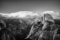
We got prime spots along the lower rail at Glacier Point in anticipation of shooting sunset. We entertained ourselves with shooting panoramas and HDRs while we waited for sunset. There were plenty of other photographers around to swap stories with, so the time went quickly. As sunset approached, white billowy clouds began peeking over the Sierra crest directly behind Half Dome and above Tenaya Canyon. The clouds continued to grow until they appeared to rise 1000 feet over Echo Peak on the Sierra crest. Although the clouds lit briefly at sunset, it was basically a dud.
The bad thing about shooting sunset at Glacier Point in the summer is that it was 11:00 before we got back to camp. It's hard to start thinking about dinner at 11:30, so I downloaded my images and went to bed.